From 1 - 9 / 9
  • This record describes Remotely Operated Vehicle (ROV) imagery collected from within the Gascoyne Marine Park offshore northwestern Australia. The ROV SuBastian was used to conduct imagery transects on 20 dives across 16 stations, including 12 quantitative transects within the Cape Range Canyon. No quantitative transects were conducted in the Cloates Canyon due to delays caused by poor weather. SuBastian is equipped with a Sulis Subsea Z70 deep sea science camera, with 4K UHD 2160p optics and sensors for temperature, depth, conductivity and oxygen. The quantitative transects were run for 500 m upslope, ideally at a speed of 0.3 knots and an altitude of 2 m above the seafloor or rock walls. Still images were acquired every 5 seconds, with additional frames added manually as required. Still images from most transects were primarily annotated onboard using the RV Falkor’s private instance of SQUIDLE+, with some post-survey annotation conducted using the public instance of Squidle+ (http://squidle.org/). See post-survey report for full methodology. http://pid.geoscience.gov.au/dataset/ga/144204

  • This record describes Remotely Operated Vehicle (ROV) imagery collected from within the Gascoyne Marine Park offshore northwestern Australia. The ROV SuBastian was used to conduct imagery transects on 20 dives across 16 stations, including 12 quantitative transects within the Cape Range Canyon. No quantitative transects were conducted in the Cloates Canyon due to delays caused by poor weather. SuBastian is equipped with a Sulis Subsea Z70 deep sea science camera, with 4K UHD 2160p optics and sensors for temperature, depth, conductivity and oxygen. The quantitative transects were run for 500 m upslope, ideally at a speed of 0.3 knots and an altitude of 2 m above the seafloor or rock walls. Still images were acquired every 5 seconds, with additional frames added manually as required. Still images from most transects were primarily annotated onboard using the RV Falkor’s private instance of SQUIDLE+, with some post-survey annotation conducted using the public instance of Squidle+ (http://squidle.org/).

  • This resource includes bathymetry data for Elizabeth and Middleton Reef within Lord Howe Marine Park collected by Geoscience Australia during the period 31 January to 6 February 2020 on the Australian Maritime College vessel, TV Bluefin. The survey was undertaken as a collaborative project funded through the National Environmental Science Program Marine Biodiversity Hub, with the Institute for Marine & Antarctic Studies (University of Tasmania), NSW Department of Primary Industries, University of Sydney (Centre for Field Robotics) and Parks Australia. The purpose of the survey was to collect baseline information for benthic habitats within the National Park Zone (Middleton Reef) and Recreational Use Zone (Elizabeth Reef) of the marine park. These data will support ongoing environmental monitoring within the Temperate East Marine Park Network as part of the 10-year management plan (2018-2028). Data acquisition for the project included seabed mapping using multibeam sonar (Kongsberg EM 2040C HD, 300 kHz), seabed imagery acquisition by Autonomous Underwater Vehicle (AUV Sirius), sediment samples (grab) and imagery of demersal fish communities by baited remote underwater video (BRUV). This dataset comprises two bathymetry grids derived from multibeam sonar data gridded at 5 m spatial resolution, covering a combined area of 312 km2 including the transit. A detailed report on the survey is provided in: Carroll, A et al. 2020. Australian Marine Park Baseline and Monitoring Survey: Post Survey Report, Middleton and Elizabeth Reefs, Lord Howe Marine Park. Report to the National Environmental Science Program, Marine Biodiversity Hub. This dataset is not to be used for navigational purposes. This dataset is published with the permission of the CEO, Geoscience Australia

  • This resource includes seabed backscatter data for South-west Corner Marine Park collected by Geoscience Australia during the periods 9 – 12 March 2020 and 27 January – 16 February 2021 on the charter vessel Santosha. The survey was undertaken as a collaborative project with the University of Western Australia, the University of Tasmania and the Australian Centre for Field Robotics (University of Sydney) and funded through the National Environmental Science Program Marine Biodiversity Hub, with co-investment by all partners and the Director of National Parks. The purpose of the project was to build baseline information for benthic habitats on the continental shelf in the marine park that will support ongoing environmental monitoring within the South-west Marine Park Network as part of the 10-year management plan (2018-2028). Data acquisition for the project included multibeam bathymetry and backscatter for an area covering 330 km^2 offshore from Cape Naturaliste to Cape Leeuwin coast, with underwater imagery of benthic communities and demersal fish collected by University of Western Australia on separate field deployments. This backscatter dataset contains a 4 m resolution 32-bit geotiff file of the survey area produced from the processed Kongsberg EM2040C multibeam sonar system data using the CMST-GA MB Process v15.04.04.0 (.64) toolbox software co-developed by the Centre for Marine Science and Technology at Curtin University and Geoscience Australia. For further information see: Giraldo-Ospina, A. et al., 2021. South-west Corner Marine Park Post Survey Report. Report to the National Environmental Science Program, Marine Biodiversity Hub.

  • This resource includes bathymetry data for South-west Corner Marine Park collected by Geoscience Australia during the periods 9 – 12 March 2020 and 27 January – 16 February 2021 on the charter vessel Santosha. The survey was undertaken as a collaborative project with the University of Western Australia, the University of Tasmania and the Australian Centre for Field Robotics (University of Sydney), and funded through the National Environmental Science Program Marine Biodiversity Hub, with co-investment by all partners and the Director of National Parks. The purpose of the project was to build baseline information for benthic habitats on the continental shelf in the marine park that will support ongoing environmental monitoring within the South-West Marine Park Network as part of the 10-year management plan (2018-2028). Data acquisition for the project included multibeam bathymetry and backscatter for an area covering 330 km^2 (excluding transit) offshore from Cape Naturaliste to Cape Leeuwin coast, with underwater imagery of benthic communities and demersal fish collected by the University of Western Australia on separate field deployments. This bathymetry dataset contains a 5 m resolution 32-bit geotiff file of the survey area produced from the processed Kongsberg EM2040C multibeam sonar system using CARIS HIPS and SIPS software. For further information see: Giraldo-Ospina, A. et al., 2021. South-west Corner Marine Park Post Survey Report. Report to the National Environmental Science Program, Marine Biodiversity Hub.

  • This resource includes backscatter data for Arafura Marine Park (Arafura Sea) collected by Geoscience Australia (GA) and the Australian Institute of Marine Science during the period 2 – 15 November 2020 on the RV Solander. The survey was undertaken as a collaborative project funded through the National Environmental Science Program Marine Biodiversity Hub, with co-investment by GA and AIMS. The purpose of the project was to build baseline information for benthic habitats in Arafura Marine Park that will support ongoing environmental monitoring within the North Marine Park Network as part of the 10-year management plan (2018-2028). Data acquisition for the project included multibeam bathymetry and backscatter for two areas (Money Shoal and Pillar Bank), seabed samples and underwater imagery of benthic communities and demersal fish. This backscatter dataset contains two 32-bit geotiff files of the backscatter mosaic for two survey areas produced from the processed EM2040C Dual Head system using the CMST-GA MB Process v15.04.04.0 (x64) toolbox software co-developed by the Centre for Marine Science and Technology at Curtin University and Geoscience Australia. A detailed report on the survey is provided in: Picard, K. Stowar, M., Roberts, N., Siwabessy, J., Abdul Wahab, M.A., Galaiduk, R., Miller, K., Nichol, S. 2021. Arafura Marine Park Post Survey Report. Report to the National Environmental Science Program, Marine Biodiversity Hub (https://www.nespmarine.edu.au/node/4505).

  • This resource includes multibeam sonar backscatter data for Middleton Reef and Elizabeth Reef within Lord Howe Marine Park collected by Geoscience Australia during the period 31 January to 6 February 2020 on the Australian Maritime College vessel, TV Bluefin. The survey was undertaken as a collaborative project funded through the National Environmental Science Program Marine Biodiversity Hub, with the Institute for Marine & Antarctic Studies (University of Tasmania), NSW Department of Primary Industries, University of Sydney (Australian Centre for Field Robotics) and Parks Australia (Marine Park managers, Commonwealth Government). The purpose of the survey was to collect baseline information for benthic habitats within the National Park Zone (Middleton Reef) and Recreational Use Zone (Elizabeth Reef) of the marine park. These data will support ongoing environmental monitoring within the Temperate East Marine Park Network as part of its 10-year management plan (2018-2028). Data acquisition for the project included seabed mapping using multibeam sonar (Kongsberg EM 2040C HD, 300 kHz), seabed imagery acquisition by Autonomous Underwater Vehicles (AUV Sirius and AUV Nimbus), sediment samples (grab) and imagery of demersal fish communities by baited remote underwater videos (BRUVs). This dataset comprises two bathymetry grids derived from multibeam sonar data gridded at 4 mspatial resolution. A detailed report on the survey is available on the Marine Biodiversity Hub’s website (https://www.nespmarine.edu.au/reports; Carroll, A et al., 2020,. Australian Marine Park Baseline and Monitoring Survey: Post Survey Report, Middleton and Elizabeth Reefs, Lord Howe Marine Park. This dataset is not to be used for navigational purposes. This dataset is published with the permission of the CEO, Geoscience Australia

  • This flythrough highlights canyon environments within the Gascoyne Marine Park offshore northwestern Australia. The Cape Range Canyon is a relatively narrow, linear canyon that initiates on the continental slope, but is connected to the shelf via a narrow channel. The walls of the canyon are steep and reveal a history of slumping and retrogressive failure, that have broadened the canyon over time. The floor contains a series of deep plunge pools, indicative of the action of sediment-laden turbidity currents in further eroding this canyon. Epibenthos within the canyons was relatively sparse and likely regulated by disturbance associated with sedimentation in the canyons. Rock overhangs often supported the highest densities of benthic suspension feeders, including glass sponges, octocorals, and ascidians. Bathymetry data and seafloor imagery for this flythrough was collected by the Schmidt Ocean Institute during survey FK200308. Funding was provided by Schmidt Ocean Institute, Geoscience Australia, the Australian Government’s National Environmental Science Program (NESP) Marine Biodiversity Hub, the Director of National Parks, and the Foundation for the WA Museum through a Woodside Marine Biodiversity Grant.
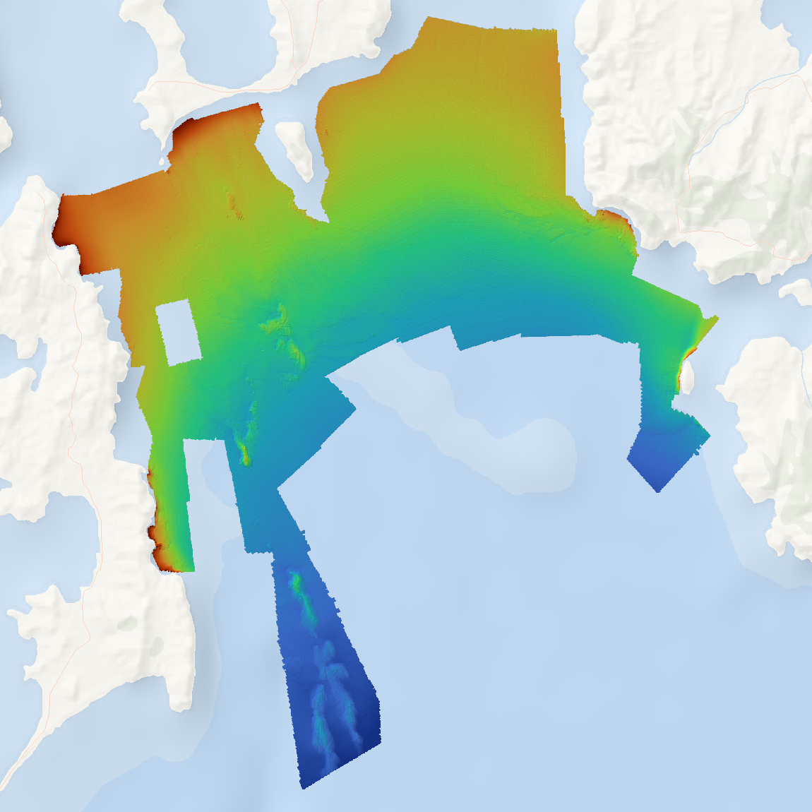
  • This resource includes bathymetry data for Arafura Marine Park (Arafura Sea) collected by Geoscience Australia (GA) and the Australian Institute of Marine Science during the period 2 – 15 November 2020 on the RV Solander. The survey was undertaken as a collaborative project funded through the National Environmental Science Program Marine Biodiversity Hub, with co-investment by GA and AIMS. The purpose of the project was to build baseline information for benthic habitats in Arafura Marine Park that will support ongoing environmental monitoring within the North Marine Park Network as part of the 10-year management plan (2018-2028). Data acquisition for the project included multibeam bathymetry and backscatter for two areas (Money Shoal and Pillar Bank), seabed samples and underwater imagery of benthic communities and demersal fish. This bathymetry dataset contains a 6 m resolution 32-bit geotiff of the survey areas produced from the processed EM2040C Dual Head system using CARIS HIPS and SIPS software. A detailed report on the survey is provided in: Picard, K. Stowar, M., Roberts, N., Siwabessy, J., Abdul Wahab, M.A., Galaiduk, R., Miller, K., Nichol, S. 2021. Arafura Marine Park Post Survey Report. Report to the National Environmental Science Program, Marine Biodiversity Hub.