 IMAS Metadata Catalogue
Countries | Countries | Australia
Type of resources
Topics
Keywords
Contact for the resource
Provided by
-
Southern right whales (Eubalaena australis) in Australia are endangered following severe depletion by commercial whaling. Australian southern right whales comprise two partially differentiated populations, a smaller eastern population and a larger western population. Encounter Bay (SA) lies near the geographic boundary between these populations and is a re-emerging calving and aggregation area. However, the population identity of whales using Encounter Bay, their subsequent coastal and offshore movements, and their exposure to anthropogenic threats is poorly understood. Four southern right whales were satellite tagged in Encounter Bay in June 2024 to investigate migratory movements, connectivity, behaviour and exposure to anthropogenic and environmental threats. The data are provided as (1) raw tracking data containing Argos satellite-tag locations; and (2) locations predicted at six-hour intervals using a state-space model, together with dive metrics summarised for the three hours before and after each modelled location. Spatial risk-exposure data are provided as rasters representing exposure of the tagged whales to climate change, entanglement, chronic underwater noise, pollution and ship strike, together with cumulative exposure across these threats. Exposure was derived by combining spatial patterns of whale occurrence with normalised threat intensity and is expressed from 0 (no exposure) to 1 (maximum exposure). Together, these data describe the coastal and offshore movements of southern right whales, and their spatial exposure to anthropogenic and environmental threats across southern Australian waters. ***EMBARGO NOTE*** This data is embargoed until June 2027. Please contact the MaC Hub Data Manager (Emma.Flukes@utas.edu.au) for access enquiries prior to this date.
-
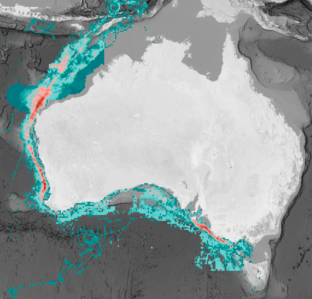
The offshore renewable energy (ORE) sector is rapidly developing in Australian waters to support national carbon emission targets. However, new marine infrastructure can introduce additional risks to threatened species. The eastern Indian Ocean pygmy blue whale (Balaenoptera musculus brevicauda) was identified by the Australian Government as a priority species for assessing potential ORE impacts. This subspecies ranges from the Subtropical Convergence (~40-45°S) to Southeast Asia (~2°S), with much of its documented distribution occurring within Australia’s Exclusive Economic Zone. Its distribution overlaps with multiple anthropogenic activities, indicating likely exposure to existing and emerging pressures. This dataset compiled available spatial information to quantify the full distribution and foraging distribution of pygmy blue whales, and to assess exposure to individual and cumulative threats across the species’ range. The threat exposure analysis incorporated expert elicitation to estimate the probability of exposure arising from spatial overlap between pygmy blue whale distribution and anthropogenic pressures, with particular focus on areas undergoing ORE development. The cumulative exposure assessment indicated relatively low exposure of pygmy blue whales to existing threats within Australian waters, including within declared ORE areas. However, several data and knowledge gaps were identified that should be addressed before further ORE development. The resulting spatial layers provide a baseline for impact assessment by industry and regulators, and support decision-making for sustainable ORE development in Australian waters.
-
This submission creates a static snapshot of data from the Autonomous Underwater Vehicle (AUV) and stereo-BRUV annotation data from the National Environmental Science Program (NESP) Elizabeth and Middleton Reef survey. More details on the survey can be found at https://www.nespmarine.edu.au/document/elizabeth-and-middleton-reefs-lord-howe-marine-park-post-survey-report.
-
Marine Protected Areas (MPAs) are widely used to support biodiversity conservation and provide ecological, social, and economic benefits, yet communicating their purpose and outcomes to public audiences remains challenging. This study tested whether closely matched MPA information presented as a static infographic or scientist-presented video incorporating baited remote underwater video (BRUV) imagery influenced objective comprehension, perceived value, and perceived credibility. A total of 338 Australian adults were randomly assigned to view either format in an online survey. There was no clear evidence that communication format influenced any outcome (for example, comprehension: OR = 1.14, 95% CI [0.91, 1.44]). Environmental and social value were higher after viewing both formats, although the study did not include a no-exposure control. Qualitative responses indicated different perceived strengths and weaknesses across formats. Overall, the findings suggest that communication outcomes may depend more on how scientific information is designed and presented within a format than on format choice alone. This record provides access to the static infographics and scientist-presented video (visual stimulus) that were shown to surveyed individuals. Access to the raw survey data is restricted due to human ethics requirements. Please contact the listed responsible parties to discuss potential access arrangements.
-
Diel partitioning of animals within ecological communities is widely acknowledged, yet rarely quantified. Investigation of most ecological patterns and processes involves convenient daylight sampling, with little consideration of the contributions of nocturnal taxa, particularly in marine environments. Here we assess diel partitioning of reef faunal assemblages at a continental scale utilizing paired day and night visual census across 54 shallow tropical and temperate reefs around Australia. Day/night differences were most pronounced in the tropics, with fishes and invertebrates displaying distinct and opposing diel occupancy on coral reefs. Tropical reefs in daytime were occupied primarily by fishes not observed at night (64% of all species sighted across day and night, and 71% of all individuals). By night, substantial emergence of invertebrates not otherwise detected during sunlit hours occurred (56% of all species, and 45% of individuals). Nocturnal emergence of tropical invertebrates corresponded with significant declines in the richness and biomass of predatory and herbivorous diurnal fishes. In contrast, relatively small diel changes in fishes active on temperate reefs corresponded to limited nocturnal emergence of temperate invertebrates. This reduced partitioning may, at least in part, be a result of strong top-down pressures from fishes on invertebrate communities, either by predation or competitive interference. For shallow reefs, the diel cycle triggers distinct emergence and retreat of faunal assemblages and associated trophic patterns and processes, which otherwise go unnoticed during hours of regular scientific monitoring. Improved understanding of reef ecology, and management of reef ecosystems, requires greater consideration of nocturnal interactions. Without explicit sampling of nocturnal patterns and processes, we may be missing up to half of the story when assessing ecological interactions.
-
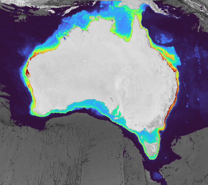
This collection contains predicted range and habitat suitability maps for 220 species of chondrichthyans (sharks, rays, and chimaeras) across Australian waters (7°–49°S, 106°–162°E, excluding offshore territories), representing approximately 68% of Australia's known chondrichthyan fauna. Occurrence records were compiled from 43 heterogeneous data sources, including national and state fisheries observer programs, scientific surveys, biodiversity repositories, acoustic telemetry networks, baited remote underwater video surveys, and beach protection programs, yielding approximately 3.37 million initial records and 2.54 million cleaned records. For all 220 species, an expert validated distribution range surface is provided. For 201 species, two additional habitat suitability prediction layers are included (~5 km resolution), derived at fixed sensitivity thresholds (95% and 90%) representing conservative estimates of the native suitable range. All outputs underwent structured expert review by taxonomic and regional specialists prior to release. Habitat suitability layers were withheld where predictions were judged to reflect sampling artefact rather than ecological signal, regardless of model performance metrics. Users should be aware that even validated suitability layers carry inherent limitations common to presence-only species distribution models at national scales, including residual sampling bias, static environmental predictors, and coarse spatial resolution (~5 km) that cannot resolve fine-scale habitat features relevant to nearshore or habitat-specialist species. These outputs are best interpreted as broad-scale indicators of environmental suitability rather than fine-scale habitat occupancy maps and should be used alongside other lines of evidence in conservation and management applications. A full description of methods, assumptions, and caveats is provided in the associated publication (De Wysiecki et al. in press). This work was funded by the Australian Government through the Parks Australia Our Marine Parks Grant (OMPG4-07), led by the Department of Primary Industries and Regional Development of Western Australia (DPIRD) in collaboration with Curtin University.
-
This metadata catalogue presents a list of the data assets used in the analysis presented in this report: Ogier, E., Sen, S., Smith, D. C., Rust, S., Magnusson, A., Jennings, S., Pethiyagoda, N., Spanou, E. (2025). Impact of COVID-19 on the Australian Seafood Industry: January 2020-June 2021 and beyond. Report prepared as part of FRDC project 2021-042: Impacts of COVID-19 on the Australian Seafood Industry: Extending the assessment to prepare for uncertain futures. Canberra, Australia, Fisheries Research and Development Corporation (FRDC).