 IMAS Metadata Catalogue
Coastal Waters (Australia) | Coastal Waters (Australia) | New South Wales Coast, NSW
Type of resources
Topics
Keywords
Contact for the resource
Provided by
-

Australia's kelp forests are among the most productive and biodiverse ecosystems on the planet. Giant kelp (Macrocystis pyrifera) can develop extensive forests and create dense surface canopies, providing a variety of ecological functions and ecosystem services including carbon sequestration, nutrient cycling and habitat provision. Giant Kelp forests naturally fluctuate from year to year and experience dramatic interannual variability. However, over the last 4–5 decades, a ~95% loss of surface-canopy forests has been recorded in eastern Tasmania due to a combination of ocean warming, changing currents, recruitment limitation, and intense herbivory by expanding sea urchin populations. While kelp forests also occur on mainland southeastern Australia, relatively little is known about the ecology of Giant Kelp in this region. In recognition of the species' rapid declines in eastern Tasmania and the lack of data elsewhere, Giant Kelp communities in Australia were declared an endangered marine community in August 2012 under the EPBC Act. Given the conservation status of Australian Giant Kelp communities, ongoing threats, and absence of a sanctioned recovery plan, there is an urgent need to establish the current extent for Giant Kelp in Australia, and to monitor changes over time. Historical aerial surveys techniques are costly, logistically difficult, and prone to cloud interference - impairing the ability of resource managers to consistently assess Giant Kelp abundance and distribution across jurisdictions. Recent improvements satellite remote sensing techniques now offer a reliable and cost-effective means for long-term kelp canopy monitoring at broad spatial and temporal scales. This project mapped the surface canopy of Giant Kelp forests from 2016 to 2023 using 3 m resolution satellite imagery across the known historical range in Tasmania, Victoria, southern New South Wales, and eastern South Australia. The mapping workflow was divided into the following broad steps: • Generate a precise land/water mask to exclude intertidal areas • Create a first-pass machine learning (ML) classification using Sentinel-2 (10 m) imagery • Acquire and process PlanetScope (3 m) daily imagery • Train and evaluate a second-pass ML model for kelp detection using PlanetScope imagery • Visualise results via an interactive Earth Engine application to enable input from expert review ---DATA DESCRIPTION--- • KelpWatch_KelpExtent_ALL_shp.zip: binary kelp extent - by year x zone (near-coast & estuary/embayment vs open water) • KelpWatch_KelpProb_ALL.zip: continuous probability of kelp - by year x zone x threshold (low vs high)
-
This record details the mapping of marine 'landforms' (geomorphic features), 'substrate type', and 'ecosystems' classified using multibeam echosounder and marine LiDAR data for the Commonwealth Solitary Islands Marine Park (SIMP) during 2022-23. Mapping was conducted using multibeam echosounder (MBES), towed-video and sediment surveys. A bathymetry mosaic was generated using data sourced from the NSW DCCEEW bathymetry mosaic (https://datasets.seed.nsw.gov.au/dataset/aa8f268e-a23d-4d27-b046-f60c45f8349b), updated with MBES data collected within SIMP in 2023. Coupled with sediment sampling and towed video surveys, the data was used to: 1) ground-truth the MBES data, 2) map the extent and characterise the diversity of unconsolidated seabed types; and, 3) map the extent of rocky reefs and characterise sessile invertebrate diversity within these reef-dominated areas. Seabed ‘landforms’ were derived from the bathymetry mosaic using the Seabed Landforms Classification Toolbox (Linklater et al. 2023). Landform features were subsequently grouped into 'hard' and 'soft' features according to the Seamap Australia National Benthic Habitat Classification Scheme (Lucieer et al. 2019), and additionally labelled with depth zonation to conform to the NESP Natural Values Common Language (Hayes et al. 2021). This package contains a synthesised seabed classification dataset, with three additional contextual datasets: • ‘SIMP_SeabedClassified’ defines seabed landforms, and reef and sediment areas delineated by depth intervals (10 m increments) classified according to the Parks Australia Natural Values Ecosystems and Seamap Australia Substratum component. See also https://datasets.seed.nsw.gov.au/dataset/f0e83f61-3790-4707-8dfe-2e505fbf3fd3 • ‘SIMP_BathyMosaicSources’ outlines the source coverages of the input bathymetric mosaic (also appended to the synthesised seabed classification dataset described above). See https://dx.doi.org/10.26186/149091 for access to bathymetry and backscatter survey data. • 'SIMP_TowedVideoSubClass' provides point classifications of the primary seabed substrate from still images derived from towed videos. See https://squidle.org/geodata/explore#map for annotated imagery. • 'SIMP_Sediments_Metadata' provides the location and associated metadata of sediment grabs. See https://pid.geoscience.gov.au/dataset/ga/69869 for access to the analysed sediment data in the MARS database. The 'Lineage' section of this record provides full methodology and a data dictionary. Surveys were funded by Parks Australia's Director of Marine Parks (Department of Climate Change, Energy, the Environment and Water) and completed under contract to the New South Wales Department of Climate Change, Energy, the Environment and Water. See Final Project Report: https://australianmarineparks.gov.au/static/734c97e56886d93a15c611222d227b33/amp-simp2024-report.pdf References: Lucieer, V., Barrett, N., Butler, C. et al. (2019). A seafloor habitat map for the Australian continental shelf. Sci Data 6, 120. https://doi.org/10.1038/s41597-019-0126-2 Hayes, K.R., Dunstan, P., Woolley, S. et al. (2021). Designing a targeted monitoring program to support evidence based management of Australian Marine Parks: A pilot on the South-East Marine Parks Network. Report to Parks Australia and the National Environmental Science Program, Marine Biodiversity Hub. Parks Australia, University of Tasmanian and CSIRO, Hobart, Australia, https://www.nespmarine.edu.au/system/files/Hayes%20et%20al_SS2_M8_D7_M4_Designing%20a%20targeted%20monitoring%20program%20to%20support%20evidence-based%20management%20of%20AMPs.pdf. Linklater, M, Morris, B.D. and Hanslow, D.J. (2023). Classification of seabed landforms on continental and island shelves. Frontiers of Marine Science, 10, https://doi.org/10.3389/fmars.2023.1258556.
-
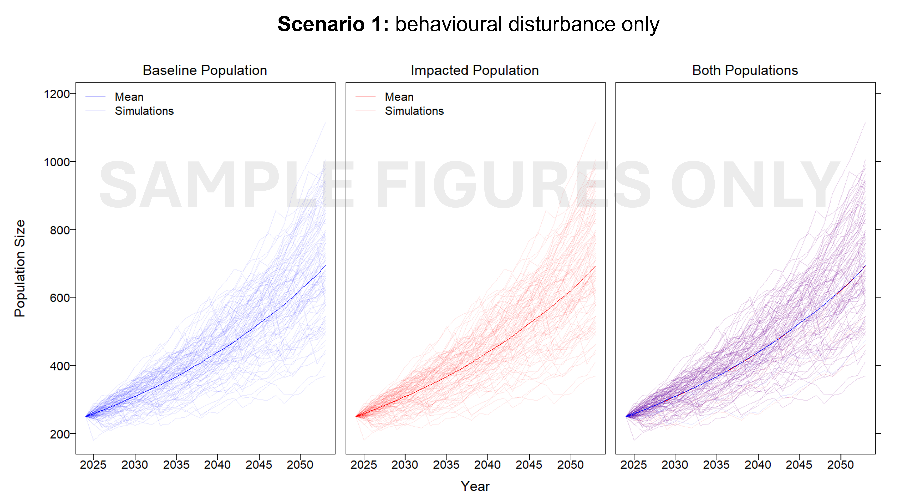
This project developed an interim Population Consequence of Disturbance (iPCoD) model for blue whales (Balaenoptera musculus) and southern right whales (Eubalaena australis) to document a methodology for assessing population-level impacts of one, or multiple, wind farm developments off the southern Australian coast. The iPCoD model was developed in Europe to quantify how disturbances of individuals caused by physiological injury or changes in behaviour can have population-level consequences in data poor marine mammal populations. This model was adapted to suit Australian marine mammal species, highlighting key data gaps for locally threatened populations that overlap in range with the declared offshore wind areas in Australia. Due to the lack of baseline data currently available, this study documented a framework that can be updated as more information becomes available. We outlined how to leverage simulation-based population modelling as a tool for policymakers, industry and management authorities, to aid in environmental impact assessments, with a specific focus on data poor marine mammal populations.