 IMAS Metadata Catalogue
Diomedea sanfordi
Type of resources
Topics
Keywords
Contact for the resource
Provided by
-
This project undertook a rapid exploration of information on a priority subset of species identified by the Department of Climate Change, Energy, the Environment and Water (DCCEEW) and the National Offshore Petroleum Safety and Environment Authority (NOPSEMA) that are listed as critically endangered or endangered under the Environment Protection and Biodiversity Conservation Act 1999. It specifically focused on these species in relation to the Gippsland declaration area, and the adjacent areas to the declaration area in Bass Strait. This rapid exploration of information was conducted as follows: 1) identify datasets and information sources relevant to priority species identified by DCCEEW and NOPSEMA for the Gippsland declaration area; 2) identify the source of these datasets and information and their level of accessibility; 3) evaluate the utility of datasets and information identified in 2) for assessments/regulatory processes required to be undertaken by DCCEEW and NOPSEMA; and 4) identify what activities would need to be undertaken to improve the accessibility and utility of datasets and information sources identified in 3) that are not currently accessible in useable formats. Fifteen priorities species (12 birds, 3 cetaceans) were identified for which publicly-available occurrence data could be located. This record and the attached download describes the data inventory for Northern Royal Albatross (Diomedea sanfordi). To download the data inventory for all fifteen priority species, see https://doi.org/10.25959/GB51-RW44.
-
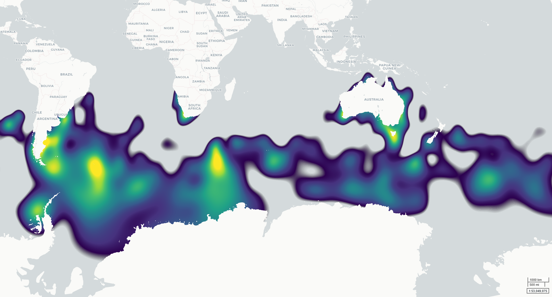
This dataset contains modelled monthly distributions of priority seabirds developed to support assessment of exposure to offshore renewable energy development as part of NESP MaC Project 4.7. Distributions are modelled for six species: Amsterdam Albatross, Gould’s Petrel, Gray-headed Albatross, Northern Royal Albatross, Shy Albatross and Southern Giant Petrel. The underlying project priority species were identified by NOPSEMA and DCCEEW, building on species priorities investigated under NESP MaC Project 3.21. Continuous integrated space-time species distribution models were fitted across the Southern Hemisphere using observations from multiple data types, including tracking, presence-absence, abundance and presence-only records. The outputs describe spatial and seasonal variation in seabird distribution on a 5 km equal-area EASE-Grid 2.0 grid. Two related raster products are provided for each modelled taxon: (1) a normalised population-distribution surface representing the relative proportion of the modelled population within each grid cell; and (2) an estimated population-density surface (individuals per km²) derived by scaling these proportions by the estimated total adult population size (Southern hemisphere). The models were developed to provide spatially and temporally explicit seabird distributions for cumulative risk assessment, including assessment of overlap with offshore renewable energy activities. Monthly outputs describe seasonal patterns across January–December. ***This data is under development. Access to the finalised spatial data will be provided once finalised, estimated early 2027.***
-
This project undertook a rapid exploration of information on a priority subset of species identified by the Department of Climate Change, Energy, the Environment and Water (DCCEEW) and the National Offshore Petroleum Safety and Environment Authority (NOPSEMA) that are listed as critically endangered or endangered under the Environment Protection and Biodiversity Conservation Act 1999. It specifically focused on these species in relation to the Gippsland declaration area, and the adjacent areas to the declaration area in Bass Strait. This rapid exploration of information was conducted as follows: 1) identify datasets and information sources relevant to priority species identified by DCCEEW and NOPSEMA for the Gippsland declaration area; 2) identify the source of these datasets and information and their level of accessibility; 3) evaluate the utility of datasets and information identified in 2) for assessments/regulatory processes required to be undertaken by DCCEEW and NOPSEMA; and 4) identify what activities would need to be undertaken to improve the accessibility and utility of datasets and information sources identified in 3) that are not currently accessible in useable formats. Fifteen priorities species (12 birds, 3 cetaceans) were identified for which publicly-available occurrence data could be located: Australian Gould's Petrel (Pterodroma leucoptera leucoptera), Curlew Sandpiper (Calidris ferruginea), Eastern Curlew (Numenius madagascariensis), Grey-headed Albatross (Thalassarche chrysostoma), Mongolian Lesser Sand Plover (Charadrius mongolus), North-Eastern Siberian Red Knot (Calidris canutus), Northern Royal Albatross (Diomedea sanfordi), Orange-bellied Parrot (Neophema chrysogaster), Swift Parrot (Lathamus discolor), Shy Albatross (Thalassarche cauta), Southern Giant Petrel (Macronectes giganteus), Wedge-Tailed Eagle (Aquila audax), Blue Whale (Balaenoptera musculus), Southern Right Whale (Eubalaena australis), Humpback Whale (Megaptera novaeangliae). The data attached to this record outlines the data sources and access points located for each of the species listed above.