 IMAS Metadata Catalogue
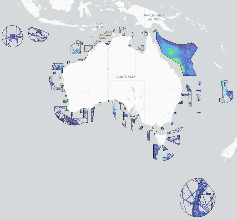
Bathymetry of the Australian Marine Parks
This dataset is a compilation product of all publicly available surveyed bathymetry within the Australian Marine Parks (AMPs, 2025 boundaries), merged into a single multi-resolution composite per AMP. The data was compiled by Seamap Australia as part of an Our Marine Parks (Parks Australia) project with funding from the Australian Government to improve knowledge relating to classification of the Australian Marine Parks real estate. This compilation of bathymetry data was the first step in generating geomorphometry classifications (see https://metadata.imas.utas.edu.au/geonetwork/srv/eng/catalog.search#/metadata/40e9283b-d4ed-4176-8fe6-112b8697003f for derived geomorphometry maps).
Bathymetry data was collated from AusSeabed data holdings ( https://portal.ga.gov.au/persona/marine), the WA Bathymetry Portal ( https://dot-wa.maps.arcgis.com/apps/webappviewer/index.html?id=d58dd77d85654783b5fc8c775953c69b), the Australian Ocean Data Network ( https://portal.aodn.org.au/) and other existing public data repositories. A single multi-resolution bathymetry mosaic, and associated multi-resolution hillshade mosaic, was generated for each AMP.
Data is supplied as a single Web Map Service of bathymetry on hillshade for the mapped regions. Data is available for download as (1) bathymetry, and (2) hillshade, Cloud-Optimised GeoTIFF (COG) files for each AMP.
The table below indicates the Parks included in this data package, and the percent coverage of bathymetric data for each. Parks not expressly listed below had no publicly accessible bathymetry data available from the sources listed in the 'lineage' section below. This dataset was last updated on 24/06/2026 and represents all public bathymetry data intersecting AMPs that could be located as of that date.
PARK....................................................% COVERAGE
Abrolhos...............................................56%
Apollo*.................................................100% (63%)
Arafura.................................................11%
Argo-Rowley Terrace............................34%
Arnhem.................................................<1%
Ashmore Reef*.....................................100% (68%)
Beagle*.................................................100% (56%)
Boags*..................................................100% (31%)
Bremer..................................................71%
Carnarvon Canyon...............................82%
Cartier Island*......................................100% (9%)
Central Eastern*...................................48% (42%)
Christmas Island*.................................44% (41%)
Cocos (Keeling) Islands*......................23% (20%)
Cod Grounds........................................98%
Coral Sea*...........................................100% (32%)
Dampier................................................61%
East Gippsland.....................................100%
Eastern Recherche...............................41%
Eighty Mile Beach.................................69%
Flinders*...............................................36% (32%)
Franklin*...............................................100% (51%)
Freycinet*.............................................60% (59%)
Gascoyne.............................................67%
Geographe...........................................25%
Gifford*.................................................100% (70%)
Great Australian Bight...........................40%
Gulf of Carpentaria................................6%
Heard & McDonald Islands*†...............100% (3%)
Hunter...................................................90%
Huon.....................................................95%
Jervis...................................................100%
Joseph Bonaparte Gulf*......................100% (0%)
Jurien...................................................20%
Kimberley*...........................................100% (14%)
Lord Howe*..........................................16% (14%)
Macquarie Island..................................100% (47%)
Mermaid Reef.......................................83%
Montebello............................................89%
Murray..................................................50%
Nelson..................................................62%
Ningaloo...............................................55%
Norfolk..................................................39%
Oceanic Shoals*..................................100% (26%)
Perth Canyon......................................100%
Roebuck..............................................100%
Shark Bay............................................16%
Solitary Islands....................................100%
Southern Kangaroo Island.....................4%
South Tasman Rise..............................82%
South-west Corner...............................53%
Tasman Fracture..................................99%
Twilight.................................................1%
Two Rocks...........................................34%
Wessel..................................................1%
West Cape York*..................................100% (11%)
Western Eyre........................................27%
Western Kangaroo Island.....................6%
Zeehan.................................................73%
* indicates Digital Elevation Model (DEM) data was included in compilation. Coverage of surveyed (non-modelled) bathymetry is shown in parentheses ()
† has been included in analysis but is not an Australian Marine Park
Simple
Identification info
- Date (Creation)
- 2023-05-31
- Date (Last Update)
- 2026-06-24
Principal investigator
Collaborator
- Credit
- Australian Government’s Our Marine Parks Grant
- Status
- On going
Point of contact
- Topic category
-
- Geoscientific information
- Elevation
Extent

Temporal extent
- Time period
- 1989-01-01
Vertical element
- Minimum value
- 0
- Maximum value
- 7000
- Identifier
- EPSG::5715
- Name
- MSL depth
- Maintenance and update frequency
- As needed
- Keywords (Theme)
-
- geomorphometry
- geomorphology
- seafloor features
- mapping
- seafloor morphology
- NASA/GCMD Keywords, Version 8.5
Resource constraints
- Classification
- Unclassified
Resource constraints
- Linkage
-
http://i.creativecommons.org/l/by/4.0/88x31.png
License Graphic
- Title
- Creative Commons Attribution 4.0 International License
- Website
-
http://creativecommons.org/licenses/by/4.0/
License Text
- Other constraints
- Cite data as: Flukes, E. & Monk, J. (2026). Bathymetry of the Australian Marine Parks [Dataset]. Institute for Marine and Antarctic Studies. Data accessed from https://metadata.imas.utas.edu.au/geonetwork/srv/eng/catalog.search#/metadata/fb451be4-9de1-4bc2-8fd6-0f285f90916f on [access date].
- Other constraints
- This dataset is the intellectual property of the University of Tasmania through the Institute for Marine and Antarctic Studies, but is a collaborative effort between AusSeabed (Geoscience Australia), the Australian Hydrographic Office, various universities and state and federal organisations around Australia. This dataset is not to be used for navigational purposes.
Associated resource
- Association Type
- Cross reference
- Initiative Type
- Study
- Title
- Geomorphometry of the Australian Marine Parks
- Website
- Related dataset
- Language
- English
- Character encoding
- UTF8
Distribution Information
- Distribution format
-
- Web Map Service, Geotiffs per AMP
- OnLine resource
- DATA ACCESS - bathymetry mosaics per AMP (COG)
- OnLine resource
- DATA ACCESS - hillshade for bathymetry mosaics (COG)
- OnLine resource
- Explore data through the interactive Seamap Australia portal
- OnLine resource
-
seamap:bathymetry_AMP_grp
Bathymetry of AMPs Web Mapping Service layer (for use in desktop GIS or similar)
Resource lineage
- Statement
- Bathymetry mosaics for each Australian Marine Park were generated by collating all available bathymetry survey data intersecting AMPs, at the highest available gridded resolution. Data was mosaiced into a single multi-resolution raster product for each AMP. All source bathymetry surveys intersecting the AMP boundaries was first projected into the most suitable UTM zone for that Park using bilinear interpolation (in cases where a park spanned multiple zones, the central-most zone was used). Reprojected rasters were then clipped to Park boundaries using the ArcGIS Pro tool CLIP RASTER. A single VRT file was generated from all homogenously projected, clipped input rasters. Datasets were ordered in the VRT such that the highest priority (aka mosaicked last) was assigned to: (1) highest resolution; and (2) most recent data (where resolution was identical. This meant that, where bathymetry datasets overlapped in the mosaic, only the first (higher resolution) data was retained for each area. In cases where input data had clear artefacts or errors, these areas were clipped out, or the input Geotiff was deprioritised in the mosaic. GDAL_TRANSLATE was then used to generate a mosaiced product with the resolution of the output file set to the highest resolution of all input data sources (bilinear interpolation). Hillshade (z-factor = 5m, azimuth = 315°, altitude = 45°) was computed for each homogenously projected, clipped input raster. These were then mosaicked into a second raster product for each AMP using the process described above. This enabled preservation of the highest-resolution hillshading detail available for each AMP. Bathymetry and hillshade mosaic datasets for each AMP were translated to COGs with DEFLATE compression applied to optimise online mapping performance.
- Hierarchy level
- Dataset
Metadata
- Metadata identifier
- urn:uuid/fb451be4-9de1-4bc2-8fd6-0f285f90916f
- Language
- English
- Character encoding
- UTF8
Point of contact
Type of resource
- Resource scope
- Dataset
- Metadata linkage
-
https://metadata.imas.utas.edu.au/geonetwork/srv/eng/catalog.search#/metadata/fb451be4-9de1-4bc2-8fd6-0f285f90916f
Point of truth URL of this metadata record
- Date info (Creation)
- 2015-05-06T11:44:25
- Date info (Revision)
- 2026-06-24T01:19:39
Metadata standard
- Title
- ISO 19115-3:2018
Overviews
Spatial extent

Provided by
