 IMAS Metadata Catalogue
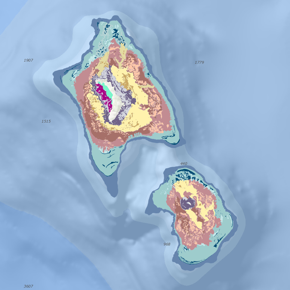
Geomorphic feature classification for Lord Howe Island and Balls Pyramid shelves
This dataset is a geomorphic classification of the shelf features surrounding Lord Howe Island and Balls Pyramid. This dataset provides information on the size, extent and type of features which occur around the shelves, which can be used for a broad range of marine planning and research purposes.
Shelves were classified into shelf region (inner, mid, outer) and geomorphic features. Features include an extensive submerged fossil reefs, ridges and patch reefs, sandy basins, paleochannels, modern fringing reef, shallow lagoon, shelf edge terraces and shelf break. Broad seafloor features were visually interpreted through digitisation in ArcGIS v10.1 using terminology consistent with international nomenclature and national standards. The classification of geomorphic features extends upon the interpretation of Balls Pyramid shelf undertaken by Linklater et al. (2015).
Full description of methods is outlined in the following open-access publication, accessible by the following link: https://doi.org/10.3390/geosciences8010011
Version 1 of the data available from https://doi.org/10.17632/8vrtxts669.1
Simple
Identification info
- Date (Publication)
- 2024-11-23T00:00:00
Resource provider
Principal investigator
- Credit
- Funding for this research was received by the Australian Government’s National Environmental Science Program Marine Biodiversity Hub. Funding was also provided by NSW Department of Primary Industries, Lord Howe Island Marine Park Authority and University of Wollongong (UOW) Research Partnerships Grant.
- Status
- Completed
Point of contact
- Topic category
-
- Geoscientific information
Extent
))
Temporal extent
- Time period
- 2018-01-02 2018-01-02
- Maintenance and update frequency
- Not planned
- Global Change Master Directory Earth Science Keywords, Version 8.5
Resource constraints
- Linkage
-
https://licensebuttons.net/l/by/4.0/88x31.png
License Graphic
- Title
- Creative Commons Attribution 4.0 International License
- Alternate title
- CC-BY
- Edition
- 4.0
- Website
-
https://creativecommons.org/licenses/by/4.0/
License Text
- Other constraints
- Cite data as: Linklater, M. (2020), Geomorphic feature classification for Lord Howe Island and Balls Pyramid shelves. Institute for Marine and Antarctic Studies. Data accessed from https://metadata.imas.utas.edu.au/geonetwork/srv/eng/catalog.search#/metadata/de9020c2-e679-4301-add2-45fd99f9d177 on [access date]
- Other constraints
- This dataset is hosted by the Institute for Marine and Antarctic Studies on behalf of the NESP Marine and Coastal Hub & University of Wollongong for the purposes of the Seamap Australia collaborative project.
- Other constraints
- Please acknowledge and cite the data with the following reference in any application of the data, including use in published works: Linklater, M., Hamylton, S.M., Brooke, B.P., Nichol, S.L., Jordan, A.R. and Woodroffe, C.D., 2018. Development of a seamless, high-resolution bathymetric model to compare reef morphology around the subtropical island shelves of Lord Howe Island and Balls Pyramid, southwest Pacific Ocean. Geosciences, 8(1), p.11. https://doi.org/10.3390/geosciences8010011
Associated resource
- Association Type
- Cross reference
- Initiative Type
- Title
- V1 of dataset (doi: 10.17632/8vrtxts669.1)
- Website
- Access version 1 of data
- Language
- English
- Character encoding
- UTF8
- Supplemental Information
- Linklater, M., Hamylton, S.M., Brooke, B.P., Nichol, S.L., Jordan, A.R. and Woodroffe, C.D., 2018. Development of a seamless, high-resolution bathymetric model to compare reef morphology around the subtropical island shelves of Lord Howe Island and Balls Pyramid, southwest Pacific Ocean. Geosciences, 8(1), p.11. https://doi.org/10.3390/geosciences8010011
Content Information
- Content type
- Physical measurement
Distribution Information
- OnLine resource
-
SHAPE-ZIP
DATA ACCESS - download geomorphic features dataset (zipped shapefile)
- OnLine resource
-
seamap:SeamapAus_NSW_LHI_BP_geomorphic_features_2018
Map of Lord Howe & Balls Pyramid shelves geomorphic features
Resource lineage
- Statement
- Broad seafloor features were visually interpreted through digitisation in ArcGIS v10.1 using terminology consistent with international nomenclature and national standards. Shelves were classified into shelf region (inner, mid, outer) and geomorphic features. The inner shelf represents the zone within approximately 1 km of the shoreline to around 30–35 m depth. Inner shelf features around Lord Howe Island were defined at a 1:6000 map scale using WV2 imagery, supplemented with ADS40 (2012) (Land and Property Information, New South Wales, Australia) aerial imagery where cloud artefacts obscured the view. The middle and outer shelf zones have varying distances from the shoreline, and typically represent the seaward 50 and 130 m isobaths, respectively. For the remaining shelf, features were digitised at 1:10,000 using slope transparently (50%) displayed over the bathymetry model. The large, mid-shelf fossil reef features were sub-divided into the upper (below 35 m depth), lower (beyond 35 m depth), and intra-reef depression (localised lows within reef structure) features.
- Hierarchy level
- Dataset
- Hierarchy level
- Dataset
Metadata
- Metadata identifier
- urn:uuid/de9020c2-e679-4301-add2-45fd99f9d177
- Language
- English
- Character encoding
- UTF8
Type of resource
- Resource scope
- Dataset
- Name
- IMAS Dataset level record
- Metadata linkage
-
https://metadata.imas.utas.edu.au/geonetwork/srv/eng/catalog.search#/metadata/de9020c2-e679-4301-add2-45fd99f9d177
Point of truth URL of this metadata record
- Date info (Creation)
- 2024-11-22T00:00:00
- Date info (Revision)
- 2025-08-14T21:23:51
Metadata standard
- Title
- ISO 19115-3:2018
Overviews
Spatial extent
Provided by
