 IMAS Metadata Catalogue
Seamounts and raised seabed features of the Australian margin (NESP MaC 2.3)
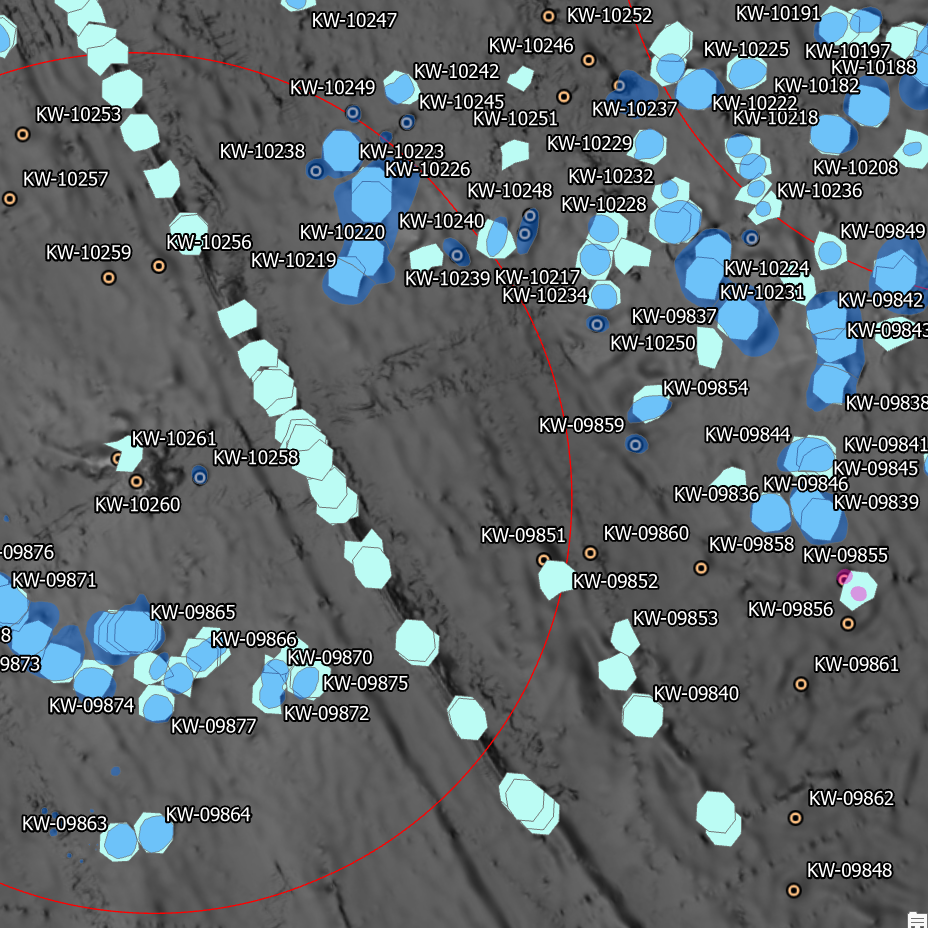
Seamounts, elevated seabed features, and bathymetric highs constitute ecologically significant habitats for various marine species, often associated with unique ecosystems and heightened biodiversity. In Australia, the absence of a comprehensive and spatially accurate inventory of these underwater structures has been a notable gap. Existing broad-scale modelling efforts, including the Parks Australia Natural Values Ecosystems (NVE) map ( https://seamapaustralia.org/map/#af207808-481a-4648-93d3-4011f2689461), have predominantly relied on coarse, global datasets. These datasets, characterized by low resolution, often fail to incorporate recent bathymetric data, leading to the omission or incorrect identification of features. This work aimed to address these limitations by developing an improved dataset of raised seabed features, specifically designed to enhance broad-scale modelling efforts like those used in the NVE mapping, and in support of the objectives of NESP Marine and Coastal Hub Project 2.3 ( https://www.nespmarinecoastal.edu.au/project/2-3/).
Seamount features were extracted from a range of data sources (see 'lineage' section of this record) for the area surrounding the Australian continental margin. These were cross-referenced with GEBCO's 2023 global terrain model (15 arc-second interval grid) and any obviously erroneous features removed. This dataset includes all features located inside the Australian Exclusive Economic Zone (EEZ). Rather than cropping exclusively to this boundary, those features falling outside the Aus EEZ but in the approximate vicinity were also retained for context
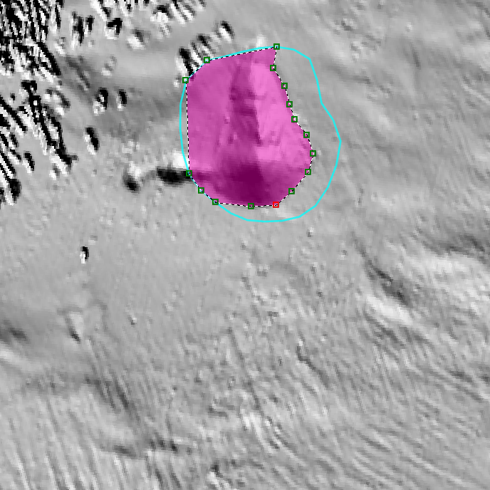
Existing feature boundaries were redigitised for areas in which more recent high-resolution bathymetry was available, utilising the 'Bathymetry of Australian Marine Parks (2024)' compilation dataset and individual survey datasets available through the AusSeabed data portal ( https://portal.ga.gov.au/persona/marine). Where available, fine-scale geomorphic mapping in which seamounts and pinnacles had been classified were extracted and merged with the larger-scale features. If fine-scale mapping disagreed with features classified in the broader-scale datasets, the finer-scale data was prioritised.
Where multiple features occurred immediately adjacent to each other, the digitised area represents the "footprint" of the features and as such, a single polygon may encompass multiple peaks. Where features could be uniquely identified (eg by a formal name/title), this attribute is included in the dataset.
Simple
Identification info
- Date (Creation)
- 2023-05-04
Identifier
- Title
- Information and documentation - Digital object identifier system
- Citation identifier
- ISO 26324:2012
- Code
- 10.25959/ZW7B-V440
- Codespace
- doi.org
- Description
- Digital Object Identifier (DOI)
Principal investigator
- Credit
- The data collections described in this record are funded by the Australian Government Department of Climate Change, Energy, the Environment and Water (DCCEEW) through the NESP Marine and Coastal Hub. In addition to NESP (DCCEEW) funding, this project is matched by an equivalent amount of in-kind support and co-investment from project partners and collaborators.
- Status
- Completed
Point of contact
- Topic category
-
- Geoscientific information
- Elevation
Extent
))
Temporal extent
- Time period
- 2023-05-04 2024-06-03
Vertical element
- Minimum value
- 0
- Maximum value
- 7000
- Identifier
- EPSG::5715
- Name
- MSL depth
- Maintenance and update frequency
- As needed
- Keywords (Project)
-
- National Environmental Science Program (NESP) Marine and Coastal Hub
- Keywords (Theme)
-
- geomorphology
- seafloor features
- seamounts
- seafloor morphology
- pinnacles
- guyots
- NASA/GCMD Keywords, Version 8.5
Resource constraints
- Classification
- Unclassified
Resource constraints
- Other constraints
- This dataset is hosted by the Institute for Marine and Antarctic Studies (IMAS), University of Tasmania, on behalf of NESP Marine and Coastal Hub Project 2.3.
Resource constraints
- Linkage
-
http://i.creativecommons.org/l/by/4.0/88x31.png
License Graphic
- Title
- Creative Commons Attribution 4.0 International License
- Website
-
http://creativecommons.org/licenses/by/4.0/
License Text
- Other constraints
- Cite data as: Flukes, E. (2024). Seamounts and raised seabed features of the Australian margin [Data set]. Institute for Marine and Antarctic Studies. https://doi.org/10.25959/ZW7B-V440
Associated resource
- Association Type
- Dependency
- Initiative Type
- Project
- Title
- NESP MaC Project 2.3 - Improving knowledge transfer to support Australian Marine Park decision making and management effectiveness evaluation, 2022-2023 (CSIRO, IMAS)
Identifier
- Language
- English
- Character encoding
- UTF8
Distribution Information
- Distribution format
-
- ESRI shapefile
- OnLine resource
-
SHAPE-ZIP
Download the data in Shapefile format
- OnLine resource
-
seamap:Aus_seamounts_raised_features
Seamounts of Australia Web Mapping Service (for use in desktop GIS or similar)
Resource lineage
- Statement
- Datasets used in this analysis: The GEBCO_2023 Grid - a continuous terrain model of the global oceans and land. https://www.gebco.net/data_and_products/gridded_bathymetry_data/gebco_2023/ Various bathymetry mapping datasets from AusSeabed (https://portal.ga.gov.au/persona/marine) Heap, A.D., Harris, P.T. 2008. Geomorphology of the Australian Margin and Adjacent Seafloor. Geoscience Australia, Canberra. http://dx.doi.org/10.1080/08120090801888669 [seamount/pinnacle features extracted] The Global Seamounts Database (KWSMTS v0.1) http://www.soest.hawaii.edu/PT/SMTS/main.html for data access Kim, S.-S., and P. Wessel (2011), New global seamount census from the altimetry-derived gravity data, Geophysical Journal International., 186, 615-631. https://doi.org/10.1111/j.1365-246X.2011.05076.x Lucieer, V. (2020). Geomorphology and Surface Classification of seven Coral Sea seamounts. Institute for Marine and Antarctic Studies (IMAS), University of Tasmania (UTAS). Data accessed from https://metadata.imas.utas.edu.au/geonetwork/srv/eng/catalog.search#/metadata/a56b2120-9753-4285-9767-f09060f8f3b8 on 10/05/2023. Lucieer, V (2018). Geomorphology map of the Huon Australian Marine Park. Institute for Marine and Antarctic Studies (IMAS), University of Tasmania (UTAS). Data accessed from http://metadata.imas.utas.edu.au/geonetwork/srv/en/metadata.show?uuid=6e9916d1-0e9c-4cf0-b08e-e5e631c1aa4d on 10/05/2023. Monk, J., Flukes, E. & Lucieer, V. (2023). Geomorphometry of Australian Marine Parks. Institute for Marine and Antarctic Studies (IMAS), University of Tasmania (UTAS). Data accessed from https://metadata.imas.utas.edu.au/geonetwork/srv/eng/catalog.search#/metadata/40e9283b-d4ed-4176-8fe6-112b8697003f on 10/05/2023. Beaman, R. (2012). Project 3DGBR: Great Barrier Reef and Coral Sea Geomorphic Features (JCU) [Dataset]. School of Earth and Environmental Sciences, James Cook University [producer]. eAtlas [distributor]. http://creativecommons.org/licenses/by/3.0/au/ [license]. Available from https://eatlas.org.au/data/uuid/25685ba5-6583-494f-974d-cce2f3429b78 Yesson, C et al. (2011): The global distribution of seamounts based on 30-second bathymetry data. Deep Sea Research Part I: Oceanographic Research Papers, 58(4), 442-453, https://doi.org/10.1016/j.dsr.2011.02.004 see https://doi.pangaea.de/10.1594/PANGAEA.757563 for 2011 data and https://doi.pangaea.de/10.1594/PANGAEA.921688 for updated 2020 data Harris, P.T., Macmillan-Lawler, M., Rupp, J. and Baker, E.K. (2014) Geomorphology of the Oceans. Marine Geology, 352, 4-24. https://doi.org/10.1016/j.margeo.2014.01.011 Guyots (via Arctic Biodiversity Data Service) https://geo.abds.is/geoserver/ebsa/ows?service=WFS&version=1.0.0&request=GetFeature&typeName=guyots&outputFormat=SHAPE-ZIP Seamounts (via Arctic Biodiversity Data Service) https://geo.abds.is/geoserver/ebsa/ows?service=WFS&version=1.0.0&request=GetFeature&typeName=seamounts&outputFormat=SHAPE-ZIP
- Hierarchy level
- Dataset
Metadata
- Metadata identifier
- urn:uuid/dc4c761f-eb4d-4fe4-b071-e110bbe7c8f3
- Language
- English
- Character encoding
- UTF8
Point of contact
Type of resource
- Resource scope
- Dataset
- Metadata linkage
-
https://metadata.imas.utas.edu.au/geonetwork/srv/eng/catalog.search#/metadata/dc4c761f-eb4d-4fe4-b071-e110bbe7c8f3
Point of truth URL of this metadata record
- Date info (Creation)
- 2015-05-06T11:44:25
- Date info (Revision)
- 2026-05-31T11:52:57
Metadata standard
- Title
- ISO 19115-3:2018
Overviews
Spatial extent
Provided by
