 IMAS Metadata Catalogue
Habitat modelling of 'functional reef' and broad-scale ecosystem components for temperate Australian waters (NESP MaC 2.1)
This record describes the outputs of two different modelling exercises that were used to characterise the seafloor habitats for temperate Australian waters. The modelled area includes all shelf waters (<250m depth) in southern Australia south of the Tropic of Capricorn. Bioregional benthic habitat maps were constructed using (1) the Geoscience Australia 250m 2023 grid (Beaman 2023); (2) ground-truthing observations derived from horizontally facing imagery from stereo-BRUV and BOSS camera systems; and (3) several physical datasets as covariates in model development (all oceanographic variables smoothed to 250m resolution). Source data is available from Geoscience Australia's eCat: https://doi.org/10.26186/148758 (bathymetry), Squidle+: (benthic imagery annotations), and (3) AODN Portal: https://portal.aodn.org.au/search (IMOS oceanographic datasets).
The specific subset of benthic observations used in this modelling exercise is available from https://github.com/UWA-Marine-Ecology-Group-projects/nesp-2.1/blob/main/data/tidy/NESP-2.1_broad-habitat.csv. See the NESP Mac Project 2.1 final report for a description of the sampling design for ground-truthing observations and annotation technique.
-----Functional Reef model (binomial)-----
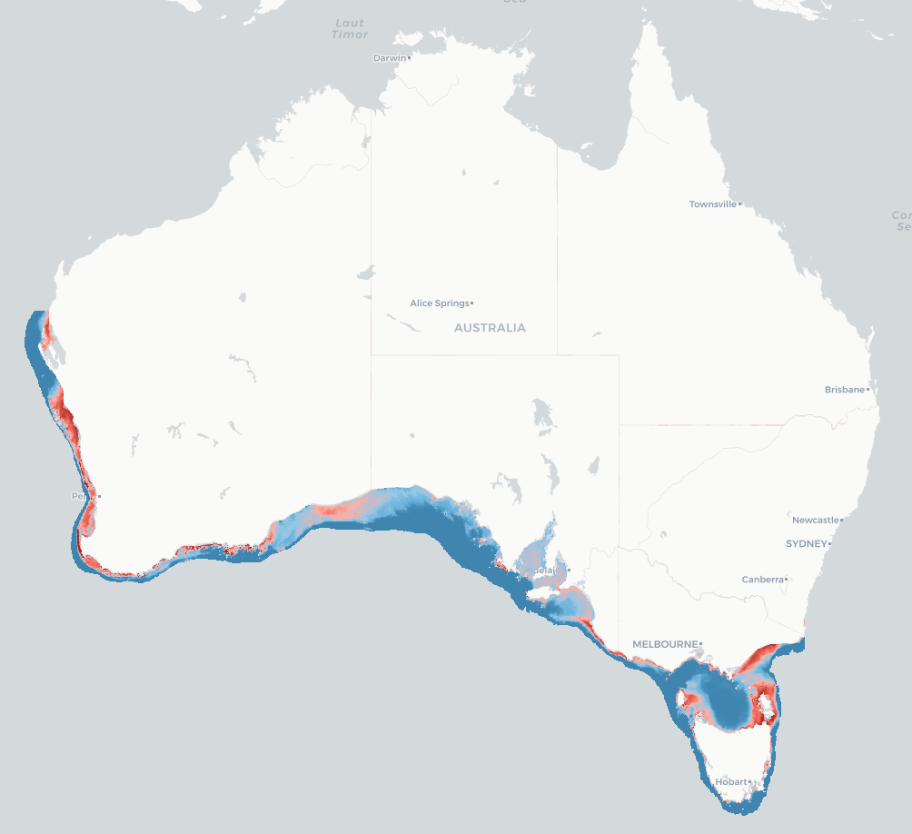
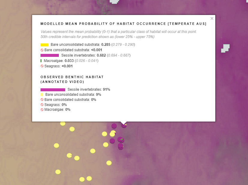
This model discriminates ‘functional reef’ from sediment (non-reef) ecosystem types. Functional reef is defined by this project as “any seabed area functioning as a reef, which may include dense beds of sessile invertebrates or molluscs”. This term was chosen because much of the continental shelf is dominated by sediment yet is stable enough to support emergent sessile biota that provide structure and resources for “reef-affiliated” species. The modelling approach uses a Bayesian representation of a Binomial generalised linear model. For ground-truthing benthic annotations, the following benthic categories were collapsed into the ‘functional reef’ classification: sessile invertebrates, bare rocky reef (consolidated), macroalgae, Amphibolis spp. and Thalassodendron spp. All other benthic classifications were assigned to the ‘non-reef’ category.
-----Ecosystem Component model (multinomial)-----
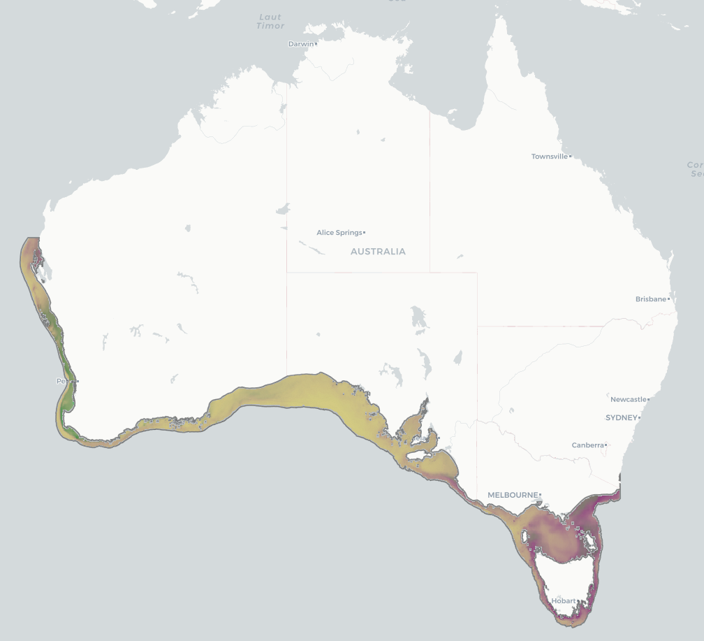
This model discriminates between five broad habitat types (hereafter ‘ecosystem components’): seagrass, macroalgae, sessile invertebrates, bare consolidated substrata, bare unconsolidated substrata. The modelling approach uses a Bayesian implementation of a Multinomial generalised linear model. For ground-truthing benthic annotations, benthic annotations for mobile species (e.g. echinodermata) were discarded. All remaining annotations were collapsed into the five broad ecosystem components.
A selection of mapping (WMS) services are listed in the 'Downloads & Links' section of this record. See the 'Lineage' section for a full description of the data packages available for download, and for more visualisation options.
Simple
Identification info
- Date (Creation)
- 2024-05-13
Identifier
- Title
- Information and documentation - Digital object identifier system
- Citation identifier
- ISO 26324:2012
- Code
- 10.25959/BVJ7-D984
- Codespace
- doi.org
- Description
- Digital Object Identifier (DOI)
Principal investigator
Principal investigator
Collaborator
Contributor
Contributor
Contributor
Contributor
Contributor
- Credit
- The data collections described in this record are funded by the Australian Government Department of Climate Change, Energy, the Environment and Water (DCCEEW) through the NESP Marine and Coastal Hub. In addition to NESP (DCCEEW) funding, this project is matched by an equivalent amount of in-kind support and co-investment from project partners and collaborators.
- Status
- Completed
Point of contact
Point of contact
- Topic category
-
- Biota
- Environment
Extent

Temporal extent
- Time period
- 2020-01-01 2024-04-30
Vertical element
- Minimum value
- 10
- Maximum value
- 250
- Identifier
- EPSG::5715
- Name
- MSL depth
- Maintenance and update frequency
- none-planned
Resource format
- Date
- Keywords (Project)
-
- National Environmental Science Program (NESP) Marine and Coastal Hub
- NASA/GCMD Keywords, Version 8.5
Resource constraints
- Classification
- Unclassified
Resource constraints
- Linkage
-
http://i.creativecommons.org/l/by/4.0/88x31.png
License Graphic
- Title
- Creative Commons Attribution 4.0 International License
- Website
-
http://creativecommons.org/licenses/by/4.0/
License Text
- Other constraints
- Cite data as: Monk, J., Langlois, T., Spencer, C., Woolley, S., Flukes, E., Gibbons, B., Bastiaansen, A., Hulls, J., Lucieer, V., Grammer, G., Hayes, K., Dunstan, P., & Barrett, N. (2024). Habitat modelling of 'functional reef' and broad-scale ecosystem components for temperate Australian waters [Data set]. Institute for Marine and Antarctic Studies. https://doi.org/10.25959/BVJ7-D984
Resource constraints
- Classification
- Unclassified
Resource constraints
- Other constraints
- This dataset is hosted by the Institute for Marine and Antarctic Studies (IMAS), University of Tasmania, on behalf NESP Marine and Coastal Hub Project 2.1.
Associated resource
- Association Type
- Dependency
- Initiative Type
- Project
- Title
- NESP MaC Project 2.1 - Mapping temperate continental shelf seabed habitats, 2022-2023 (IMAS, UWA)
Identifier
- Language
- English
- Character encoding
- UTF8
Distribution Information
- Distribution format
-
- GeoTIFF
- OnLine resource
- DATA ACCESS - Full data package (.zip of above)
- OnLine resource
- View & explore Functional Reef model outputs in Seamap Australia
- OnLine resource
-
View & explore Ecosystem Component model outputs in Seamap Australia
Additional outputs available under Seafloor Habitat > Predicted Habitats > Bivariate probability..., or search for 'bivariate probability'
- OnLine resource
- Project page on NESP Marine and Coastal Hub website
- OnLine resource
-
TemperateAus_broadscale_predArea_binomial_reef
MAP - Functional Reef mean prediction
- OnLine resource
-
TemperateAus_binomial_predicted_reef_ERROR
MAP - Functional Reef bivariate probability
- OnLine resource
-
TemperateAus_broadscale_predArea_bivariateProb_reef
MAP - Functional Reef bivariate probability of occurrence
- OnLine resource
-
TemperateAus_broadscale_predArea_multinomial_habitat
MAP - Ecosystem Components mean prediction [combination view]
- OnLine resource
-
TemperateAus_broadscale_predArea_bivariateProb_sessile_inverts
MAP - Sessile Invertebrates bivariate probability of occurrence
- OnLine resource
-
TemperateAus_broadscale_predArea_bivariateProb_seagrass
MAP - Seagrass bivariate probability of occurrence
- OnLine resource
-
TemperateAus_broadscale_predArea_bivariateProb_macroalgae
MAP - Macroalgae bivariate probability of occurrence
- OnLine resource
-
TemperateAus_broadscale_predArea_bivariateProb_consolidated
MAP - Bare Consolidated (bare rocky reef) bivariate probability of occurrence
- OnLine resource
-
TemperateAus_broadscale_predArea_bivariateProb_unconsolidated
MAP - Bare Unconsolidated (bare sediment) bivariate probability of occurrence
Resource lineage
- Statement
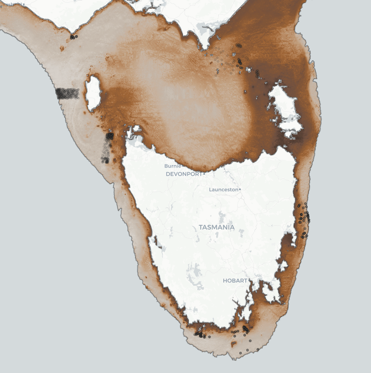
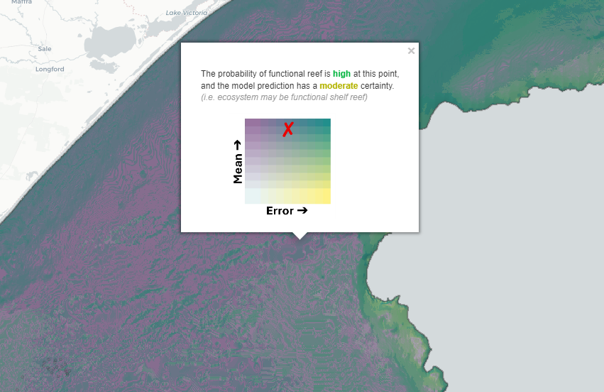
- See NESP Marine and Coastal Project 2.1 final report for a full for a description of the sampling design, annotation technique, and modelling approach. A key objective of this modelling approach was to effectively report the spatial uncertainty associated with model predictions to assist with conservation and management assessments. The outputs from both the Functional Reef and Ecosystem Component models is presented in two alternative ways. VISUALISATION OPTION #1 The first approach presents model outputs as a map of the mean probability of occurrence for reef or each ecosystem class, with uncertainty (inter-quartile range (IQR) error of prediction) shown as a separate map that can be viewed in parallel. The data packages for both the binomial reef and multinomial ecosystem models contain ReadMe files describing the data structure: -----Functional Reef (binomial)----- https://data.imas.utas.edu.au/attachments/seamap_predicted_habitat/temperate_aus/model_outputs/reef_binomial/ProbabilityOfOccurrence -----Ecosystem Components (multinomial)----- https://data.imas.utas.edu.au/attachments/seamap_predicted_habitat/temperate_aus/model_outputs/ecosystemComponents_multinomial/ProbabilityOfOccurrence VISUALISATION OPTION #2 The second uncertainty mapping approach reports a map of the expected probability of occurrence (mean prediction) combined with the IQR error of prediction in a single raster, where each combination of mean x error (10 error quantiles x 10 mean quantiles = 100 unique raster values) is plotted along a bivariate colour gradient. The colour scales are shown on two axes, with y showing the probability of occurrence (or “likelihood”) and x representing the error in those predictions (or “(un)certainty”). The data package for both the binomial reef and multinomial ecosystem models contain ReadMe files describing the data structure: -----Functional Reef (binomial)----- https://data.imas.utas.edu.au/attachments/seamap_predicted_habitat/temperate_aus/model_outputs/reef_binomial/BivariateUncertainty -----Ecosystem Components (multinomial)----- https://data.imas.utas.edu.au/attachments/seamap_predicted_habitat/temperate_aus/model_outputs/ecosystemComponents_multinomial/BivariateUncertainty
- Hierarchy level
- Dataset
Metadata
- Metadata identifier
- urn:uuid/b349c610-32c5-4574-ae8e-43cbf204e8bc
- Language
- English
- Character encoding
- UTF8
Point of contact
- Parent metadata
Type of resource
- Resource scope
- Dataset
- Metadata linkage
-
https://metadata.imas.utas.edu.au/geonetwork/srv/eng/catalog.search#/metadata/b349c610-32c5-4574-ae8e-43cbf204e8bc
Point of truth URL of this metadata record
- Date info (Creation)
- 2024-05-13T11:44:25
- Date info (Revision)
- 2026-05-31T11:19:26
Metadata standard
- Title
- ISO 19115-3:2018
Overviews

Spatial extent

Provided by
