 IMAS Metadata Catalogue
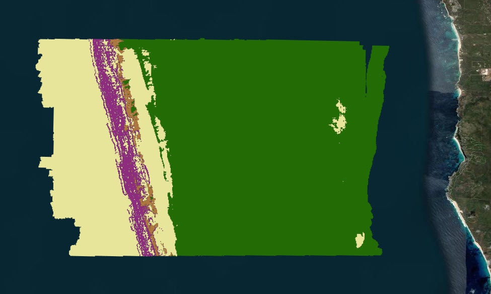
Predictions of dominant habitat from the South-west Corner Marine Park (NESP MaC 1.4)
Predictions of dominant habitats were completed as part of a report funded by the NESP Marine & Coastal Hub. This report focussed on an IUCN II zone in the South-west Corner Marine Park off the 'Capes region' near Margaret River. This modelling contains data from stereo Baited Remote Underwater Video and panoramic drop camera, and was completed using the FSS-GAM package in R. Predictions are at two different scales and resolutions, one using the broad 250 metre resolution Geoscience Australia 2009 bathymetry grid ( http://dx.doi.org/10.4225/25/53D99B6581B9A) and the other using a 5 metre resolution Geoscience Australia multibeam survey ( https://dx.doi.org/10.26186/145281).
Simple
Identification info
- Date (Creation)
- 2022-07-04
Identifier
- Title
- Information and documentation - Digital object identifier system
- Citation identifier
- ISO 26324:2012
- Code
- 10.25959/S1SW-RJ21
- Codespace
- doi.org
- Description
- Digital Object Identifier (DOI)
Principal investigator
Collaborator
Collaborator
Collaborator
- Credit
- The data collections described in this record are funded by the Australian Government Department of Climate Change, Energy, the Environment and Water (DCCEEW) through the NESP Marine and Coastal Hub. In addition to NESP (DCCEEW) funding, this project is matched by an equivalent amount of in-kind support and co-investment from project partners and collaborators.
- Status
- Completed
Point of contact
- Topic category
-
- Biota
Extent

Temporal extent
- Time period
- 2020-03-01 2021-03-31
Vertical element
- Minimum value
- 35
- Maximum value
- 355
- Identifier
- EPSG::5715
- Name
- MSL depth
- Maintenance and update frequency
- none-planned
- Keywords (Project)
-
- National Environmental Science Program (NESP) Marine and Coastal Hub
- GCMD Earth Science Keywords
Resource constraints
- Classification
- Unclassified
Resource constraints
- Other constraints
- This dataset is hosted by the Institute for Marine and Antarctic Studies (IMAS), University of Tasmania, on behalf of The University of Western Australia and NESP Marine and Coastal Hub Project 1.4.
Resource constraints
- Linkage
-
http://i.creativecommons.org/l/by/4.0/88x31.png
License Graphic
- Title
- Creative Commons Attribution 4.0 International License
- Website
-
http://creativecommons.org/licenses/by/4.0/
License Text
- Other constraints
- Cite data as: Langlois, T., Spencer, C., Gibbons, B., & Monk, J. (2022). Predictions of dominant habitat from the South-west Corner Marine Park [Data set]. Institute for Marine and Antarctic Studies. https://doi.org/10.25959/S1SW-RJ21
Associated resource
- Association Type
- Dependency
- Initiative Type
- Project
- Title
- NESP MaC Project 1.4 - Characterising values and identifying indicators and metrics of fish and benthic assemblages within the Capes region of the South-west Corner Marine Park (UWA)
Identifier
- Language
- English
- Character encoding
- UTF8
Content Information
- Content type
- Physical measurement
Identifier
- Code
- Abundance of biota
- Identifier
- http://vocab.nerc.ac.uk/collection/P06/current/UPCT
- Name
- Percent
- Description
- Appended to original data for styling purposes for the Seamap Australia Project.
- Name
- Benthic habitat
- Name
- SM_HAB_CLS
Distribution Information
- Distribution format
-
- GeoTIF & Shapefile
- OnLine resource
-
SHAPE-ZIP
Download the data (finescale habitats) as Shapefile via WFS
- OnLine resource
-
SHAPE-ZIP
Download the data (broadscale habitats) as Shapefile via WFS
- OnLine resource
-
seamap:SeamapAus_WA_SWCorner_domhab_fine_2021
MAP - Southwest Corner finescale habitat
- OnLine resource
-
seamap:SeamapAus_WA_SWCorner_domhab_broad_2021
MAP - Southwest Corner broadscale habitat
Resource lineage
- Statement
- Data were collected using stereo Baited Remote Underwater Video and panoramic drop camera, and were analysed using the fss-GAM package in R following workflows described in Fisher et al. 2018. The predictions of dominant habitat type were conducted at 2 scales using the broad 250m bathymetry from Geoscience Australia, and using a fine 4m resolution multibeam survey from Geoscience Australia. For all datasets, 0 = Macroalgae, 1 = Sand, 2 = Sessile invertebrates & 3 = Rock.
- Hierarchy level
- Dataset
Metadata
- Metadata identifier
- urn:uuid/9ada4f7f-abf2-468b-a158-e1c7dba11b92
- Language
- English
- Character encoding
- UTF8
Point of contact
- Parent metadata
Type of resource
- Resource scope
- Dataset
- Metadata linkage
-
https://metadata.imas.utas.edu.au/geonetwork/srv/eng/catalog.search#/metadata/9ada4f7f-abf2-468b-a158-e1c7dba11b92
Point of truth URL of this metadata record
- Date info (Creation)
- 2015-05-06T11:44:25
- Date info (Revision)
- 2026-05-31T11:52:22
Metadata standard
- Title
- ISO 19115-3:2018
Overviews

Spatial extent

Provided by
