 IMAS Metadata Catalogue
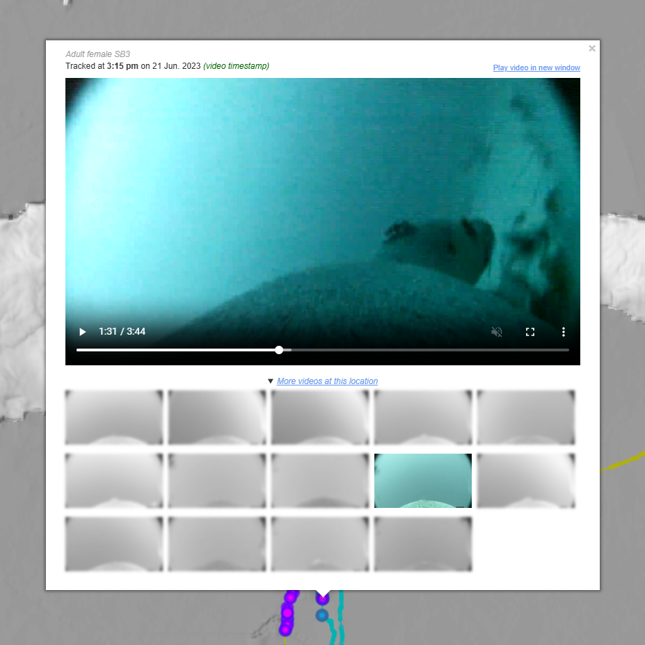
Mapping critical Australian sea lion habitat with animal-borne instruments (NESP MaC 2.6)
This project aimed to identify and map critical habitats for Australian sea lions (Neophoca cinerea) to assess the ecological value of different habitats, and identify risks to their populations. Video imagery, GPS, time-depth and accelerometer/magnetometer data was captured from eight adult female Australian sea lions from Olive Island (n=4) on the western Eyre Peninsula and Seal Bay (n=4) on Kangaroo Island in South Australia. Sea lions were instrumented with animal-borne cameras with integrated accelerometers/magnetometers (CATS Cam, 135 x 96 x 40 mm, 400 g) and satellite-linked GPS loggers with integrated time-depth recorders (SPLASH-10, Wildlife Computers, 100 x 65 x 32 mm, 200 g). Sea lions were sedated and anaesthetised and bio-logging instruments were glued to the pelage on the dorsal midline. Bio-logging instruments were recovered after a single foraging trip (~1-6 days).
The data collected in this project provides fundamental information on critical benthic habitats for Australian sea lions, the differences in foraging behaviour of individual sea lions, and their prey preferences. This information improves our understanding of threats to sea lion populations and will support future conservation actions to recover the species.
Simple
Identification info
- Date (Publication)
- 2023-11-16
- Date (Revision)
- 2024-07-16
Identifier
- Title
- Information and documentation - Digital object identifier system
- Citation identifier
- ISO 26324:2012
- Code
- 10.25959/MBR6-F262
- Codespace
- doi.org
- Description
- Digital Object Identifier (DOI)
Principal investigator
Principal investigator
Collaborator
- Credit
- The data collections described in this record are funded by the Australian Government Department of Climate Change, Energy, the Environment and Water (DCCEEW) through the NESP Marine and Coastal Hub. In addition to NESP (DCCEEW) funding, this project is matched by an equivalent amount of in-kind support and co-investment from project partners and collaborators.
- Credit
- The Ecological Society of Australia (Holsworth Wildlife Research Endowment)
- Credit
- Department of Primary Industries and Regions SA
- Credit
- Department for Environment and Water
- Credit
- Far West Coast Aboriginal Corporation
- Status
- Completed
Point of contact
- Topic category
-
- Biota
- Oceans
Extent
))
))
Temporal extent
- Time period
- 2022-12-02 2023-08-26
Vertical element
- Minimum value
- 0
- Maximum value
- 170
- Identifier
- EPSG::5715
- Name
- MSL depth
- Maintenance and update frequency
- Not planned
- Keywords (Project)
-
- National Environmental Science Program (NESP) Marine and Coastal Hub
- Keywords (Theme)
-
- Animal-borne video
- Satellite-linked GPS logger
- Time-depth recorder
- Accelerometer
- Magnetometer
- Bio-logging
- Benthic habitats
- Habitat mapping
- Foraging behaviour
- Predation
- Southern Australia
- Continental shelf
- Keywords (Taxon)
-
- Australian sea lion
- Pinniped
- Otariid
- Global Change Master Directory Earth Science Keywords, Version 8.5
- AODN Discovery Parameter Vocabulary
-
- Animal-borne video
- Time-depth data
- GPS data
- Accelerometer data
- Magnetometer data
Resource constraints
- Classification
- Unclassified
Resource constraints
- Other constraints
- This dataset is hosted by the University of Tasmania, on behalf of SARDI and The University of Adelaide and NESP Marine and Coastal Hub Project 2.6.
Resource constraints
- Linkage
-
https://licensebuttons.net/l/by/4.0/88x31.png
License Graphic
- Title
- Creative Commons Attribution 4.0 International License
- Alternate title
- CC-BY
- Edition
- 4.0
- Website
-
https://creativecommons.org/licenses/by/4.0/
License Text
- Other constraints
- Cite data as: Goldsworthy, S., Angelakis, N., & Kirkwood, R. (2024). Mapping critical Australian sea lion habitat with animal-borne instruments [Data set]. Institute for Marine and Antarctic Studies. https://doi.org/10.25959/MBR6-F262
Associated resource
- Association Type
- Dependency
- Initiative Type
- Project
- Title
- NESP MaC Project 2.6 - Mapping critical Australian sea lion habitat to assess ecological value and risks to population recovery, 2022-2024 (SARDI)
Identifier
- Language
- English
- Character encoding
- UTF8
Content Information
- Content type
- Physical measurement
Identifier
- Code
- Animal-borne video
- Name
- N/A
Identifier
- Code
- Time-depth data
- Identifier
- http://vocab.nerc.ac.uk/collection/P06/current/ULAA
- Name
- Metres
Identifier
- Code
- GPS data
- Name
- Latitude/Longitude (decimal degrees)
Identifier
- Code
- Accelerometer data
- Identifier
- http://vocab.nerc.ac.uk/collection/P06/current/UTHZ
- Name
- Hertz
Identifier
- Code
- Magnetometer data
- Identifier
- http://vocab.nerc.ac.uk/collection/P06/current/UTHZ
- Name
- Hertz
Distribution Information
- Distribution format
-
- CSV files and MOV video files
- OnLine resource
- DATA ACCESS - selectively browse and download video and tracking files by sea lion individual [warning: video download packages may be large]
- OnLine resource
- View & explore sea lion videos and tracking data in the Seamap Australia mapping portal
- OnLine resource
-
MaC_2_6_AusSeaLions_video_tracking
Tracking and animal-borne video from Australian Sea Lions (for use in desktop GIS or mapping portals)
Resource lineage
- Statement
- Eight adult female Australian sea lions from Olive Island (n=4) and Seal Bay (n=4) in South Australia were instrumented with animal-borne cameras with integrated accelerometers/magnetometers (CATS Cam, 135 x 96 x 40 mm, 400 g) and satellite-linked GPS loggers with integrated time-depth recorders ((SPLASH-10, Wildlife Computers, 100 x 65 x 32 mm, 200 g). Sea lions were sedated and anaesthetised and bio-logging instruments were glued to the pelage on the dorsal midline. Bio-logging instruments were recovered after a single foraging trip (~1-6 days). High-definition video (anterior perspective) was collected while animals were at sea, at depths greater than 5 meters, during daylight hours (between 0800-1700 local time). Batteries in the camera allowed ~13 hours of filming, this regime hence enabled filming coverage of 2-3 days of time at sea. Satellite-linked GPS loggers collected Fastloc® locations when animals surfaced, by capturing a sub-second snapshot of signals from orbiting satellite constellations at two-minute intervals (the minimum rate programmable). When dive durations exceeded two minutes, locations were sought when the device next surfaced. Locations obtained from four or fewer satellites were discarded. Time-depth recorders (TDRs) measured depth every second. Tria-axial accelerometers measured body movement (G-force), for surge (anterior-posterior), sway (lateral) and heave (dorsal-ventral) axes at 20 Hz. Tri-axial magnetometers measured the earth’s magnetic field intensity in microteslas (µT) for roll (longitudinal, north), pitch (transverse, east) and yaw (vertical, down) axes at 1 Hz. ---DATA STRUCTURE--- Data is organised into a folder for each sea lion, containing the following sub-folders: - CATS Cam Files: Direct data export from CATS camera. The CSV file contains all the dive and environmental attributes recorded by the CATS camera, e.g. accelerometer (units: m/s²), magnetometer (units: μT), depth (units: m), light (raw units: for triggering camera), temperature (°C). - CATS Video Files: Contains all video files collected by the CATS camera. Each filename contains datetime (local) in the YYYYMMDD-HHMMSS - Wildlife Computers File: Contains the raw file from the Wildlife Computers SPLASH-10 tag (users will need the Mk10 Host software, downloaded from the Wildlife Computers website, to open this file). Exported GPS data in a non-proprietary format is contained in the next folder (GPS). - GPS: contains the GPS information collected by the Wildlife Computers SPLASH-10 tag (note these are the files generated when the raw Wildlife Computers file (.wch) is processed to generate the FastLoc GPS locations (KMZ file) on the Wildlife Computers Data Portal site). Users will most likely want the Locations.csv or FastLocGPS.kmz file, which contains lat/lon, datetime, and a quality score for the captured satellite information. - TDR: contains the depth file collected by the Wildlife Computers SPLASH-10 tag (this is the file generated when the raw Wildlife Computers file (.wch) is opened in the Mk10 Host software) ---VISUALISATIONS--- Mapping visualisations are available for select aspects of this data collection at the WMS endpoints described in this record. For visualisations, spurious GPS locations (typically >5km from adjacent GPS fixes, or otherwise indicating unrealistic movement speeds) were removed. Note that the raw data contains all GPS information reported by the FastLoc system
- Hierarchy level
- Dataset
- Hierarchy level
- Dataset
Metadata
- Metadata identifier
- urn:uuid/84cb1709-a669-4f2c-b97b-5eceb7929349
- Language
- English
- Character encoding
- UTF8
Point of contact
Type of resource
- Resource scope
- Dataset
- Name
- IMAS Dataset level record
- Metadata linkage
-
https://metadata.imas.utas.edu.au/geonetwork/srv/eng/catalog.search#/metadata/84cb1709-a669-4f2c-b97b-5eceb7929349
Point of truth URL of this metadata record
- Date info (Creation)
- 2023-11-16T00:00:00
- Date info (Revision)
- 2026-05-31T11:23:03
Metadata standard
- Title
- ISO 19115-3:2018
Overviews

Spatial extent
Provided by
