 IMAS Metadata Catalogue
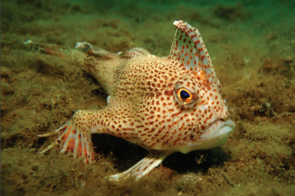
Spotted Handfish (Brachionichthys hirsutus) - GPS Underwater Visual Census - 2014-2022 repeated population surveys (NESP MB A10; NESP MaC 1.23)
Dive surveys were conducted in 2014 and the same sites resurveyed annually until 2022 (excluding 2021), to establish a baseline and monitor the status of the critically endangered spotted handfish (Brachionichthys hirsutus) population. This dataset is a summary of all surveys season 2014 to 2022 (excluding 2021) in which the 11 sites across the Derwent Estuary and D'Entrecasteaux Channel were assessed. The data describes the search effort (transect length, swathed area) and counts of handfish observed on each transect, including size measurements (total length) and depth records for each sighted fish.
Simple
Identification info
- Date (Revision)
- 2022-12-31
Identifier
- Title
- Information and documentation - Digital object identifier system
- Citation identifier
- ISO 26324:2012
- Code
- 10.25959/6PYW-AK73
- Codespace
- doi.org
- Description
- Digital Object Identifier (DOI)
Principal investigator
Collaborator
Collaborator
- Credit
- The data collections described in this record are funded by the Australian Government Department of Climate Change, Energy, the Environment and Water (DCCEEW) through the NESP Marine and Coastal Hub and previously NESP Marine Biodiversity Hub. In addition to NESP (DCCEEW) funding, this project is matched by an equivalent amount of in-kind support and co-investment from project partners and collaborators.
- Status
- Completed
Point of contact
Point of contact
- Topic category
-
- Biota
Extent

Temporal extent
- Time period
- 2014-02-28 2022-11-03
Vertical element
- Minimum value
- 2
- Maximum value
- 20
- Identifier
- EPSG::5715
- Name
- MSL depth
- Maintenance and update frequency
- Annually
- Keywords (Project)
-
- National Environmental Science Program (NESP) Marine and Coastal Hub
- Keywords (Taxon)
-
- Brachionichthys hirsutus
Resource constraints
- Classification
- Unclassified
Resource constraints
- Other constraints
- This dataset is hosted by the Institute for Marine and Antarctic Studies (IMAS), University of Tasmania, on behalf NESP Marine Biodiversity Hub A10 & NESP Marine and Coastal Hub Project 1.3.
Resource constraints
- Linkage
-
http://i.creativecommons.org/l/by/4.0/88x31.png
License Graphic
- Title
- Creative Commons Attribution 4.0 International License
- Website
-
http://creativecommons.org/licenses/by/4.0/
License Text
- Other constraints
- Cite data as: Lynch, T., Stuart-Smith, J., Devine, C., McEnnulty, F., & Wong, L. (2022). Spotted Handfish (Brachionichthys hirsutus) - GPS Underwater Visual Census - 2014-2022 repeated population surveys [Data set]. Institute for Marine and Antarctic Studies. https://doi.org/10.25959/6PYW-AK73
Associated resource
- Title
- NESP MB Project A10 - Conservation of handfish and their habitat, 2016-2020 (IMAS, CSIRO)
Identifier
- Association Type
- Dependency
- Initiative Type
- Project
Associated resource
- Title
- NESP MaC Project 1.23 - Conservation of spotted handfish, 2021-2022 (CSIRO)
Identifier
- Association Type
- Dependency
- Initiative Type
- Project
- Language
- English
- Character encoding
- UTF8
- Supplemental Information
- Lynch T, Green M and Davies C. 2015. Short communication: Diver towed GPS to estimate densities of a critically endangered fish. Biological Conservation 191:700-706. Lynch T,, Green M, Davies C. Diver towed GPS increases both statistical power to estimate densities and functionality to observe behaviours of sparsely distributed spotted handfish (Brachionichthys hirsutus, Lacépède 1804). Biological Conservation. 2015; 191(1 1):700-706. Wong LSC, Lynch TP, Barrett NS, Wright JT, Green MA, Flynn DJH (2018) Local densities and habitat preference of the critically endangered spotted handfish (Brachionichthys hirsutus): Large scale field trial of GPS parameterised underwater visual census and diver attached camera. PLoS ONE 13(8): e0201518. https://doi.org/10.1371/journal.pone.0201518
Content Information
- Content type
- Physical measurement
- Description
- Count of Spotted Handfish along transect
Identifier
- Code
- Abundance of biota
- Name
- Body length of Spotted Handfish
- Name
- Fish_length_mm
- Identifier
- http://vocab.nerc.ac.uk/collection/P06/current/UXMM
- Name
- Millimetres
- Name
- Depth of sighted Spotted Handfish
- Name
- Sighted_depth_m
- Identifier
- http://vocab.nerc.ac.uk/collection/P06/current/ULAA
- Name
- Metres
- Description
- 0 – No visible stress 1 – Threat display visible (dorsal, caudal fins erected) 2 – Movement visible, predominantly short distance 'walk' 3 – Escape response, short burst swim
- Name
- Stress response of fish
- Name
- Fish_Stress_Response
- Name
- Start time of dive transect (local)
- Name
- Time_Start
- Name
- End time of dive transect (local)
- Name
- Time_End
- Name
- Area of seafloor searched
- Name
- Swath_Area_m2
- Identifier
- http://vocab.nerc.ac.uk/collection/P06/current/UMSQ
- Name
- Square metres
Distribution Information
- OnLine resource
- SUPPLEMENTARY DATA - Summary population statistics 1998 - 2019
- OnLine resource
-
NESP:CSIRO_NESP_handfish_surveys
MAP - Spotted Handfish surveys
- OnLine resource
-
CSIRO_NESP_handfish_surveys
This OGC WFS service returns the data for download in subsettable CSV format.
- OnLine resource
-
Associated Publication
Lynch, Tim; Green, Mark; Wong, Lincoln; Bessell, Tyson; Cooper, A. J.; Valentine, J; Barrett, Neville; Ross, Jeff; McEnnulty, Felicity; Foster, Scott. Assessment of conservations actions for the critically endangered spotted handfish (Brachionichthyidae), following curation of data collected by multiple investigators into a long-term time-series. Journal for Nature Conservation. 2022; 69(126237):1-12. doi:10.1016/j.jnc.2022.126237
- OnLine resource
-
Associated Publication
Wong LSC, Lynch TP, Barrett NS, Wright JT, Green MA, Flynn DJH (2018) Local densities and habitat preference of the critically endangered spotted handfish (Brachionichthys hirsutus): Large scale field trial of GPS parameterised underwater visual census and diver attached camera. PLoS ONE 13(8): e0201518. doi:10.1371/journal.pone.0201518
- OnLine resource
-
Associated Publication
Lynch, T., Green, M. & Davies, C. Diver-towed GPS to estimate densities of a critically endangered fish. Biological Conservation 191 (2015): 700-706.
- OnLine resource
-
Associated Publication
Lynch, Tim; Green, Mark; Davies, Claire. Diver towed GPS increases both statistical power to estimate densities and functionality to observe behaviours of sparsely distributed spotted handfish (Brachionichthys hirsutus, Lacépède 1804). Biological Conservation. 2015; 191(1 1):700-706. doi:102.100.100/91758
Resource lineage
- Statement
- Population surveys of spotted handfish (Brachionichthys hirsutus) were conducted during the non-breeding season (March – August) of 2014-2019. Surveys were conducted at 9 different location within the Derwent Estuary and 2 additional location in D'Entrecasteaux Channel. Data were collected using a variable length, GPS tracked underwater visual census method. Divers swam abreast approximately 0.5m-1m above the sediment to search for fish while towing a surface float with GPS housed onboard. The GPS tracked the position of the divers in real time and allowed extraction of spatial data post-hoc to determine searched distance to parameterise each transect. When B. hirsutus were located along the transect a series of photographs were taken to record the time of the sighting for cross-referencing with GPS spatial logs to determine the location of each sighting. The total length of each fish was measured to the nearest millimetre using a ruler placed laterally adjacent to the fish.
- Hierarchy level
- Dataset
- Hierarchy level
- Dataset
Platform
Identifier
- Code
- diver
Metadata
- Metadata identifier
- urn:uuid/51702b57-d4e4-4477-b199-b3485675f66c
Point of contact
Type of resource
- Resource scope
- Dataset
- Metadata linkage
-
https://metadata.imas.utas.edu.au/geonetwork/srv/eng/catalog.search#/metadata/51702b57-d4e4-4477-b199-b3485675f66c
Point of truth URL of this metadata record
- Date info (Creation)
- 2020-09-10T08:09:11
- Date info (Revision)
- 2026-05-31T11:54:36
Metadata standard
- Title
- ISO 19115-3:2018
Overviews
Spatial extent

Provided by
