 IMAS Metadata Catalogue
Geomorphometry of the Australian Marine Parks
This dataset provides geomorphic features of the Australian Marine Parks (2022). The data was generated by Seamap Australia as part of an Our Marine Parks (Parks Australia) project with funding from the Australian Government to improve knowledge relating to classification of the Australian Marine Parks real estate.
Bathymetry data was collated from existing AusSeabed data holdings and compiled into multi-resolution bathymetry mosaics for each Park (see https://metadata.imas.utas.edu.au/geonetwork/srv/eng/catalog.search#/metadata/fb451be4-9de1-4bc2-8fd6-0f285f90916f). All publicly available bathymetry data as at 30th June 2022 was included. Macquarie Island was updated on 25/08/2023 to reflect the new AMP boundaries.
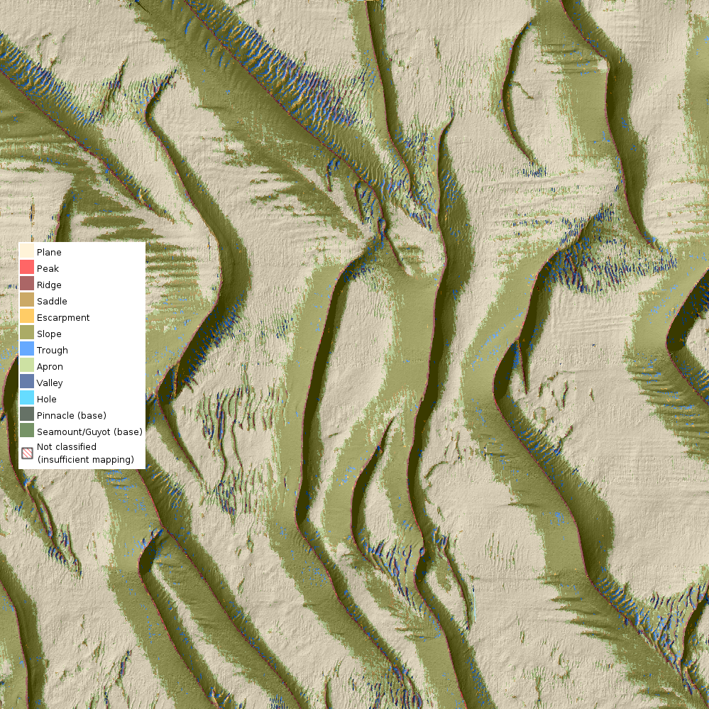
The Whitebox tools package in R was used to calculate geomorphometry using the geomorphron function. Processing for each Park was addressed manually, with search distances and slope thresholds adjusted between Parks depending on quality and resolution of bathymetry data, and characteristics of the seafloor. Geomorphons were classified into geomorphic features using the Dove et al (2020) Seabed Morphology Features Glossary. These geomorphic units provide a consistent way to classify the seabed and may be used in combination with visual validation methods to develop benthic habitat maps.
Data is supplied as a Web Map Service of geomorphic features overlaid on hillshade for the mapped regions. Data is available for download as a zipped package of geotiffs with accompanying hillshade. ESRI .lyr file and QGIS .sld files are supplied for display in desktop GIS.
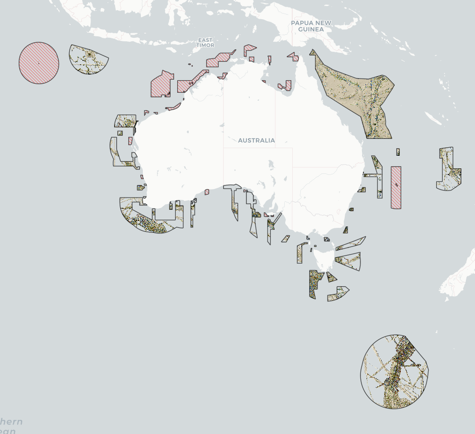
All Parks with 25% or more bathymetry coverage were included in processing.
The table below indicates the Parks included in this data package, and the percent coverage of geomorphic data for each, based on the bathymetry coverage available at the time of processing. Note that the current coverage of bathymetry may be greater than that expressed below and contained within this data package, for areas in which more recent surveys have been published.
PARK % COVERAGE
Abrolhos 36%
Apollo 52%
Beagle 35%
Boags 31%
Bremer 70%
Carnarvon Canyon 72%
Central Eastern* 47% (41%)
Christmas Island* 31% (28%)
Cod Grounds 97%
Coral Sea* 100% (30%)
East Gippsland 96%
Eastern Recherche 29%
Flinders 30%
Franklin 51%
Freycinet 40%
Gascoyne 53%
Geographe 25%
Gifford 100%
Great Australian Bight 36%
Heard & McDonald Islands*† 100% (0%)
Hunter 90%
Huon 94%
Jervis 99%
Macquarie Island 40%
Mermaid Reef 72%
Murray 47%
Nelson 58%
Ningaloo 54%
Norfolk 38%
Perth Canyon 98%
Solitary Islands 34%
South Tasman Rise 59%
South-west Corner 46%
Tasman Fracture 99%
Two Rocks 27%
Western Eyre 25%
Zeehan 74%
* indicates Digital Elevation Model (DEM) data was included in analysis. Coverage of surveyed (non-modelled) bathymetry is shown in parentheses ()
† has been included in analysis but is not an Australian Marine Park
For glossary of features, see:
Dove et al. (2020) A two-part seabed geomorphology classification scheme (v.2); Part 1: morphology features glossary. http://dx.doi.org/10.5281/ZENODO.4075248
Simple
Identification info
- Date (Creation)
- 2022-07-04
Principal investigator
Principal investigator
Distributor
- Credit
- Australian Government’s Our Marine Parks Grant
- Status
- On going
Point of contact
- Topic category
-
- Geoscientific information
Extent

Temporal extent
- Time period
- 2022-01-01
Vertical element
- Minimum value
- 0
- Maximum value
- 7000
- Identifier
- EPSG::5715
- Name
- MSL depth
- Maintenance and update frequency
- As needed
- Keywords (Theme)
-
- geomorphometry
- geomorphology
- seafloor features
- mapping
- seafloor morphology
- NASA/GCMD Keywords, Version 8.5
Resource constraints
- Classification
- Unclassified
Resource constraints
- Linkage
-
http://i.creativecommons.org/l/by/4.0/88x31.png
License Graphic
- Title
- Creative Commons Attribution 4.0 International License
- Website
-
http://creativecommons.org/licenses/by/4.0/
License Text
- Other constraints
- Cite data as: Monk, J., Flukes, E. & Lucieer, V. (2022). Geomorphometry of Australian Marine Parks. Institute for Marine and Antarctic Studies (IMAS), University of Tasmania (UTAS). Data accessed from https://metadata.imas.utas.edu.au/geonetwork/srv/eng/catalog.search#/metadata/40e9283b-d4ed-4176-8fe6-112b8697003f on [access date].
- Other constraints
- This dataset is the intellectual property of the University of Tasmania through the Institute for Marine and Antarctic Studies.
- Language
- English
- Character encoding
- UTF8
- Supplemental Information
- Lucieer V, Flukes E, Monk J and Walsh P (2024) Geomorphometric maps of Australia’s Marine Park estate and their role in improving the integrated monitoring and management of marine ecosystems. Front. Mar. Sci. 10:1302108. doi: 10.3389/fmars.2023.1302108
Distribution Information
- Distribution format
-
- Web Map Service, Geotiffs per AMP
- OnLine resource
- DATA ACCESS - geomorphometry classification Geotiffs
- OnLine resource
- RELATED DATA - bathymetry mosaics of AMPs (source data)
- OnLine resource
-
SUPPLEMENTARY - code and RMarkdown Notebook workflow for geomorphic classification [GitHub repo]
- OnLine resource
-
seamap:geomorph_AMP_grp
Geomorphometry of AMPs Web Mapping Service layer (for use in desktop GIS or similar)
Resource lineage
- Statement
- Geomorphometry of the Australian Marine Parks was calculated using geomorphon function in the Whitebox tools package (version 2.1.5) in R. Specific search distances and slope thresholds varied between parks, ranging from 10-100 cells for the search distances and 1.5-10 degrees for slope. Bathymetry was collated from existing holdings within AusSeaBed portal. The raster cell resolution of some Marine Parks was up-scaled to allow for efficient processing. Example dataset, R code, and specific distance and slope parameters are provided in "Example_workflow.zip" in this submission
- Hierarchy level
- Dataset
Metadata
- Metadata identifier
- urn:uuid/40e9283b-d4ed-4176-8fe6-112b8697003f
- Language
- English
- Character encoding
- UTF8
Point of contact
Type of resource
- Resource scope
- Dataset
- Metadata linkage
-
https://metadata.imas.utas.edu.au/geonetwork/srv/eng/catalog.search#/metadata/40e9283b-d4ed-4176-8fe6-112b8697003f
Point of truth URL of this metadata record
- Date info (Creation)
- 2015-05-06T11:44:25
- Date info (Revision)
- 2024-04-16T12:34:11
Metadata standard
- Title
- ISO 19115-3:2018
Overviews
Spatial extent

Provided by
