 IMAS Metadata Catalogue
Shark and Ray National SDM Project - Predicted habitat suitability for Australian chondrichthyans
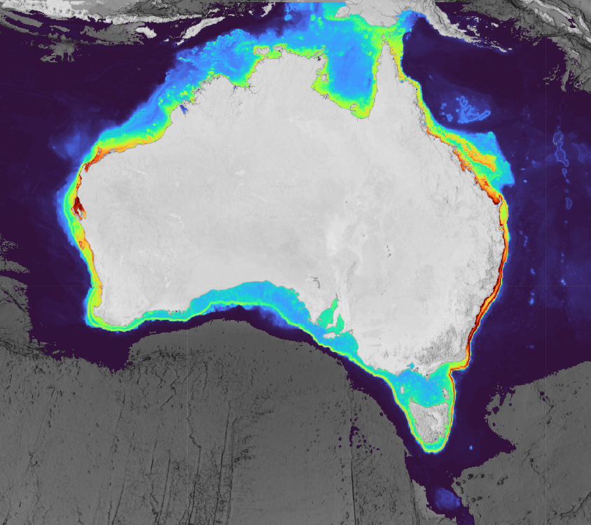
This collection contains predicted range and habitat suitability maps for 220 species of chondrichthyans (sharks, rays, and chimaeras) across Australian waters (7°–49°S, 106°–162°E, excluding offshore territories), representing approximately 68% of Australia's known chondrichthyan fauna.
Occurrence records were compiled from 43 heterogeneous data sources, including national and state fisheries observer programs, scientific surveys, biodiversity repositories, acoustic telemetry networks, baited remote underwater video surveys, and beach protection programs, yielding approximately 3.37 million initial records and 2.54 million cleaned records. For all 220 species, an expert validated distribution range surface is provided. For 201 species, two additional habitat suitability prediction layers are included (~5 km resolution), derived at fixed sensitivity thresholds (95% and 90%) representing conservative estimates of the native suitable range.
All outputs underwent structured expert review by taxonomic and regional specialists prior to release. Habitat suitability layers were withheld where predictions were judged to reflect sampling artefact rather than ecological signal, regardless of model performance metrics. Users should be aware that even validated suitability layers carry inherent limitations common to presence-only species distribution models at national scales, including residual sampling bias, static environmental predictors, and coarse spatial resolution (~5 km) that cannot resolve fine-scale habitat features relevant to nearshore or habitat-specialist species. These outputs are best interpreted as broad-scale indicators of environmental suitability rather than fine-scale habitat occupancy maps and should be used alongside other lines of evidence in conservation and management applications. A full description of methods, assumptions, and caveats is provided in the associated publication (De Wysiecki et al. in press).
This work was funded by the Australian Government through the Parks Australia Our Marine Parks Grant (OMPG4-07), led by the Department of Primary Industries and Regional Development of Western Australia (DPIRD) in collaboration with Curtin University.
Simple
Identification info
- Date (Publication)
- 2026-07-31T00:00:00
- Edition
- Version 1.0
Identifier
- Title
- Information and documentation - Digital object identifier system
- Citation identifier
- ISO 26324:2012
- Code
- 10.25959/Y7B0-BT97
- Codespace
- doi.org
- Description
- Digital Object Identifier (DOI)
Resource provider
Principal investigator
Principal investigator
Collaborator
- Purpose
- Predictions are intended to support marine biodiversity assessment, marine spatial planning, fisheries bycatch risk assessment, and conservation management across Australia's network of marine protected areas.
- Credit
- AFMA and all State Fisheries Departments, as well as the QLD Shark Control and NSW Shark Meshing programs provided catch and survey data. GlobalArchive and The Fish Collective for providing access to the Australian BRUVs synthesised data for which quality control was provided using CheckEM. IMOS repository provided national telemetry data. More than 20 collaborators across national and state fisheries, universities, and research institutes provided data and expertise during the project.
- Status
- Completed
Point of contact
Point of contact
- Topic category
-
- Biota
Extent
))
Temporal extent
- Time period
- 2025-01-10 2026-10-18
- Maintenance and update frequency
- As needed
- Keywords (Theme)
-
- Species Distribution Models
- Chondrichthyans
- Sharks and rays
- Data Integration
- Seamap
- Map predictions
- Bio-Oracle
- Modelling Framework
- Global Change Master Directory Earth Science Keywords, Version 8.5
Resource constraints
- Linkage
-
https://licensebuttons.net/l/by/4.0/88x31.png
License Graphic
- Title
- Creative Commons Attribution 4.0 International License
- Alternate title
- CC-BY
- Edition
- 4.0
- Website
-
https://creativecommons.org/licenses/by/4.0/
License Text
- Other constraints
- Cite data as: Braccini, M., De Wysiecki, A. M. & Harvey, E. S. (2026). Shark and Ray National SDM Project - Predicted habitat suitability for Australian chondrichthyans (Version 1.0) [Dataset]. Institute for Marine and Antarctic Studies. https://doi.org/10.25959/Y7B0-BT97
Resource constraints
- Other constraints
- This dataset is the intellectual property of DPIRD (WA Government) and Curtin University.
- Language
- English
- Character encoding
- UTF8
Distribution Information
- OnLine resource
- Explore habitat suitability predictions for 220 species of chondrichthyans in Seamap Australia
- OnLine resource
-
Download habitat suitability predictions
Available as individual files per species (1–3 bands), or as multiband stacks containing all species for each model output type.
- OnLine resource
- Calibration file of species observations used for SDMs
Resource lineage
- Statement
- Habitat suitability predictions were generated using a dual-track ensemble species distribution modelling (SDM) framework implemented in R. Species with ≥50 occurrence records (n = 152) were modelled using a standard multi-algorithm ensemble combining eight algorithms (GLM, GAM, GAU, MaxEnt, RF, SVM, GBM, and ANN); species with 20–49 records (n = 68) were modelled using an Ensemble of Small Models (ESM) approach across seven algorithms. Prior to modelling, occurrence records underwent spatial and taxonomic quality control, including coordinate validation, taxonomic standardisation, expert validation through collaborative workshops, and environmental filtering to reduce spatial autocorrelation and sampling bias. The final calibration dataset used as input for the species distribution models (SDMs) comprises ~20,500 occurrence records, following species-specific data filtering and expert-based processing to ensure suitability for model calibration. Environmental predictors were sourced from Bio-ORACLE v3.0 as decadal averages (2000–2020) at 0.05° resolution (~5 km) and were selected according to each species' primary habitat association (pelagic, epibenthic, or deepwater). Model performance was evaluated using the Continuous Boyce Index and AUC under spatial block cross-validation. Final ensemble predictions were weighted by individual model performance scores and projected across the study region. Post-processing steps included extrapolation masking using the Mobility-Oriented Parity metric and a dispersal-based distance-decay constraint to limit predictions beyond ecologically accessible areas. 𝗗𝗮𝘁𝗮 𝗙𝗶𝗹𝗲𝘀 SDM predictions are available for download as individual files per species (1–3 bands) from the folder 𝗽𝗲𝗿_𝘀𝗽𝗲𝗰𝗶𝗲𝘀, or as multiband stacks containing all species for each model output type (folder 𝗼𝘂𝘁𝗽𝘂𝘁_𝘀𝘁𝗮𝗰𝗸). A cumulative habitat suitability layer (summed habitat suitability across all species) is additionally available (folder 𝗰𝘂𝗺𝘂𝗹𝗮𝘁𝗶𝘃𝗲). The final cleaned, validated and environmentally filtered occurrence records used to calibrate the SDM are available from 𝗦𝗗𝗠_𝗰𝗮𝗹𝗶𝗯𝗿𝗮𝘁𝗶𝗼𝗻_𝗿𝗲𝗰𝗼𝗿𝗱𝘀_𝗮𝗹𝗹𝗦𝗽𝗽.𝗰𝘀𝘃.
- Hierarchy level
- Dataset
Metadata
- Metadata identifier
- urn:uuid/35916744-f7a6-4dbe-b1e1-f6d213528f0c
- Language
- English
- Character encoding
- UTF8
Type of resource
- Resource scope
- Dataset
- Name
- IMAS Dataset level record
- Metadata linkage
-
https://metadata.imas.utas.edu.au/geonetwork/srv/eng/catalog.search#/metadata/35916744-f7a6-4dbe-b1e1-f6d213528f0c
Point of truth URL of this metadata record
- Date info (Creation)
- 2026-05-26T00:00:00
- Date info (Revision)
- 2026-10-24T18:02:13
Metadata standard
- Title
- ISO 19115-3:2018
Overviews
Spatial extent
Provided by