 IMAS Metadata Catalogue
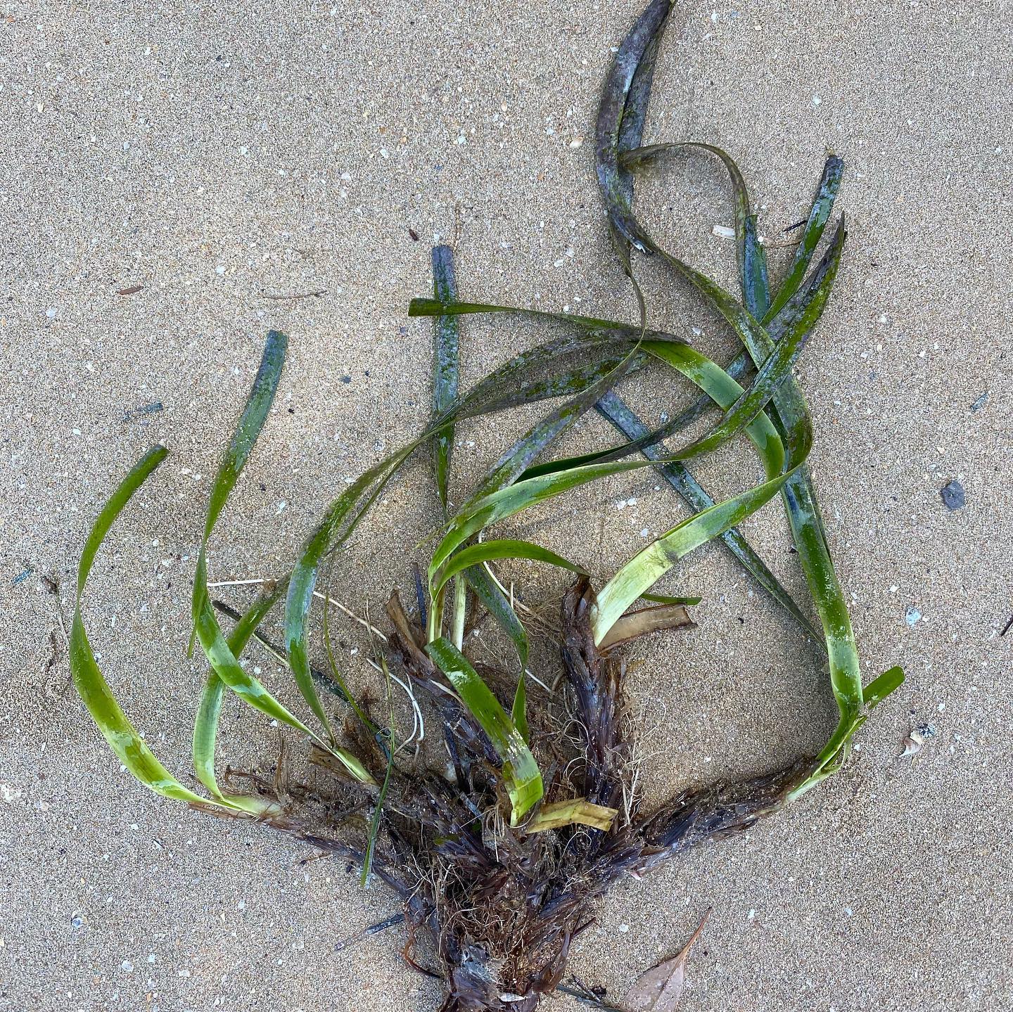
Locations and health of beachcast fragments of Posidonia in Botany Bay (NESP MaC 1.8)
Efforts to restore Posidonia seagrass meadows in NSW are reliant on collecting beachcast fragments as collection of donor material from extant beds is prohibited. However, to maximise the collection efforts it necessary to understand where to collect fragments from and what environmental conditions (e.g. wind direction, wind strength, tidal height) increase the availability of fragments and where to collect the most healthy fragments. This data set captures the abundance of fragments at 7 sites in Gamay (Botany Bay), an area of interest for restoration of Posidonia australis. It investigates how characteristics of wind (speed and direction), tidal height and swell (height, direction) influence the availability (abundance) and health (as determined by observations of necrosis) of shoots at sites throughout Botany Bay.
The Excel data workbook is comprised of two sheets:
Fragments_data sheet shows the number of P. australis fragments collected at different sites, when they were collected, and the environmental conditions at collection (see data attributes section).
Shoot_data sheet shows the proportion of necrosis of shoots attached to collected fragments.
Simple
Identification info
- Date (Creation)
- 2022-04-11
Identifier
- Title
- Information and documentation - Digital object identifier system
- Citation identifier
- ISO 26324:2012
- Code
- 10.25959/77RT-S809
- Codespace
- doi.org
- Description
- Digital Object Identifier (DOI)
Collaborator
- Credit
- Research was funded by 'Wild Elements Foundation Wild Innovator Award' to Prof. Adriana Vergés.
- Credit
- The data collections described in this record are funded by the Australian Government Department of Climate Change, Energy, the Environment and Water (DCCEEW) through the NESP Marine and Coastal Hub. In addition to NESP (DCCEEW) funding, this project is matched by an equivalent amount of in-kind support and co-investment from project partners and collaborators.
- Status
- Completed
Point of contact
- Topic category
-
- Biota
Extent
))
))
))
))
))
))
))
Temporal extent
- Time period
- 2021-09-29 2021-11-07
- Maintenance and update frequency
- none-planned
- Keywords (Project)
-
- National Environmental Science Program (NESP) Marine and Coastal Hub
- Keywords (Theme)
-
- Botany Bay
- Gamay
- restoration
- seagrass
- shoot collection
- Keywords (Taxon)
-
- Posidonia australis
- GCMD Earth Science Keywords
Resource constraints
- Classification
- Unclassified
Resource constraints
- Other constraints
- This dataset is hosted by the Institute for Marine and Antarctic Studies (IMAS), University of Tasmania, on behalf of NESP Marine and Coastal Hub Project 1.8.
Resource constraints
- Linkage
-
http://i.creativecommons.org/l/by/4.0/88x31.png
License Graphic
- Title
- Creative Commons Attribution 4.0 International License
- Website
-
http://creativecommons.org/licenses/by/4.0/
License Text
- Other constraints
- Liddell, B. (2023). Locations and health of beachcast fragments of Posidonia in Botany Bay [Data set]. Institute for Marine and Antarctic Studies. https://doi.org/10.25959/77RT-S809
- Other constraints
- The data described in this record are the intellectual property of the Gamay Rangers (WA).
Associated resource
- Title
- NESP MaC Project 1.8 - Including sediment processes in restoration strategies for Australian seagrass ecosystems, 2021-2022 (UNSW)
Identifier
- Association Type
- Dependency
- Initiative Type
- Project
- Language
- English
- Character encoding
- UTF8
Content Information
- Content type
- Physical measurement
- Name
- Full or partial survey of beach
- Name
- Full_Partial
- Name
- -
- Name
- No. of Posidonia australis fragments collected
- Name
- Fragments
- Name
- -
- Name
- Length of shoreline searched
- Name
- Search_length
- Name
- m
- Name
- Tide_heights
- Name
- Tide height
- Name
- m
- Name
- Wind speed at time of survey
- Name
- Wind_speed
- Name
- km/h
- Name
- Direction of wind
- Name
- Wind_direction
- Name
- compass
- Name
- Wind speed at 3pm the day prior to survey
- Name
- Prior_wind_speed
- Name
- km/h
- Name
- Wind direction at 3pm the day prior to survey
- Name
- Prior_wind_direction
- Name
- km/h
- Name
- Height of swell
- Name
- Swell_height
- Name
- m
- Name
- Direction of swell
- Name
- Swell_direction
- Name
- compass
- Name
- Swell height at 3pm the day prior to survey
- Name
- Prior_swell_height
- Name
- m
- Name
- No. of shoots on a plant used to determine % necrosis
- Name
- Shoots
- Name
- -
- Name
- Proportion of necrosis of total shoot area measured
- Name
- Necrosis
- Name
- proportion (0.0-1.0)
Distribution Information
- Distribution format
-
- Microsoft Excel
- OnLine resource
- DATA ACCESS - Posidonia wrack data [direct download]
Resource lineage
- Statement
- Beach surveys were conducted to record number of Posidonia australis fragments. Surveys (n=39) were completed between 29/09/2021 and 7/11/2021. Dates and sites surveyed each day was dependent upon vessel availability and weather conditions as some sites are only accessible via vessel. The study surveyed 7 beaches in Gamay (Botany Bay). The beaches included Yarra Bay Beach, Frenchman’s Bay Beach, Congwong Beach, Brighton Le Sands Beach, Dolls Point Beach, Silver Beach, and Towra beach. As some of the beaches are large, it was not always feasible to walk the entire stretch of beach (these were termed ‘partial’ surveys). Sections of large beaches were identified as suitable to survey, taking beach access into consideration. Brighton Le Sands survey area was between (-33.969910 LAT , 151.153128 LNG) and (-33.979260 LAT , 151.149984 LNG). Silver Beach survey area was between (-34.005092 LAT , 151.217101 LNG) and (-34.008107 LAT , 151.204953 LNG). The entire beach was surveyed for all other sites. For each survey the surveyor recorded time, beach name, start and finish coordinates, as well as number of fragments found. Each fragment’s location was also recorded along with the number of shoots (leaves on each fragment) and necrosis percentage (visualised at areas of dead white tissue). Tide, wind (at time of survey and 3pm the day prior), and swell were recorded post survey. Wind speed and direction data was collected from the Bureau of Meteorology website (http://www.bom.gov.au/). Swell height and direction data was collected from Manly Hydraulics Lab website (https://www.mhl.nsw.gov.au/). Tide data sourced from ‘Willy Weather’ mobile app. All coordinates were obtained from ‘Google Earth’ on either mobile app or desktop.
- Hierarchy level
- Dataset
Metadata
- Metadata identifier
- urn:uuid/15dca9a6-766a-46d9-8b1b-f9466e724c7a
- Language
- English
- Character encoding
- UTF8
Point of contact
- Parent metadata
Type of resource
- Resource scope
- Dataset
- Metadata linkage
-
https://metadata.imas.utas.edu.au/geonetwork/srv/eng/catalog.search#/metadata/15dca9a6-766a-46d9-8b1b-f9466e724c7a
Point of truth URL of this metadata record
- Date info (Creation)
- 2015-05-06T11:44:25
- Date info (Revision)
- 2026-05-31T11:22:44
Metadata standard
- Title
- ISO 19115-3:2018
Overviews
Spatial extent
Provided by
