 IMAS Metadata Catalogue
Popup satellite archival tag (PSAT) time series of skates caught around Heard Island
Time series dataset of depth and activity recorded by miniPAT (Wildlife computers) popup satellite archival tags deployed on Kerguelen sandpaper skates (Bathyraja irrasa, n=24) caught in the Patagonian toothfish longline fishery in Heard Island and McDonald Islands.
Tags were deployed to assess the post-release survival of skates in the fishery.
Simple
Identification info
- Date (Publication)
- 2025-01-07T00:00:00
Identifier
- Title
- Information and documentation - Digital object identifier system
- Citation identifier
- ISO 26324:2012
- Code
- 10.25959/ZT9D-VQ94
- Codespace
- doi.org
- Description
- Digital Object Identifier (DOI)
Principal investigator
Collaborator
Collaborator
- Credit
- Funded by Australian Fisheries Management Authority (AFMA) and Fisheries Research Development Corporation (FRDC)
- Status
- Completed
Point of contact
Institute for Marine and Antarctic Studies - Appert, Colette
University of Tasmania
Tasmania
Australia
- Topic category
-
- Oceans
- Biota
Extent
N
S
E
W
))
Temporal extent
- Time period
- 2023-04-23 2023-07-12
Vertical element
- Minimum value
- 0
- Maximum value
- 1750
- Identifier
- EPSG::5715
- Name
- MSL depth
- Maintenance and update frequency
- Not planned
- Keywords (Theme)
-
- Post-release survival
- Mortality
- Bycatch
- Telemetry
- PSAT
- MiniPAT
- Benthic
- Keywords (Taxon)
-
- Elasmobranch
- Skate
- Bathyraja irrasa
- Global Change Master Directory Earth Science Keywords, Version 8.5
Resource constraints
- Use limitation
- Data, products and services from IMAS are provided "as is" without any warranty as to fitness for a particular purpose.
Resource constraints
- Linkage
-
https://licensebuttons.net/l/by-nc/4.0/88x31.png
License Graphic
- Title
- Creative Commons Attribution-NonCommercial 4.0 International License
- Alternate title
- CC-BY-NC
- Edition
- 4.0
- Website
-
https://creativecommons.org/licenses/by-nc/4.0/
License Text
- Other constraints
- Cite data as: Appert, C., Cleeland, J., & Tracey, S. (2025). Popup satellite archival tag (PSAT) time series of skates caught around Heard Island [Data set]. Institute for Marine and Antarctic Studies. https://doi.org/10.25959/ZT9D-VQ94
- Other constraints
- This dataset is the intellectual property of the University of Tasmania (UTAS) through the Institute for Marine and Antarctic Studies (IMAS).
- Language
- English
- Character encoding
- UTF8
- Supplemental Information
- Appert, C., Wolfe, B., Tracey, S., Masere, C., Wotherspoon S., & Cleeland, J. "Behavioural indicators of post-release survival in a deep-sea skate", Proceedings of the Royal Society B: Biological Sciences. doi: 10.1098/rspb.2025.1345
Distribution Information
- Distribution format
-
- CSV
- OnLine resource
- DATA ACCESS - miniPAT tag data
- OnLine resource
- Associated files & Rdata code
- OnLine resource
-
Associated publication
Appert, C., Wolfe, B., Tracey, S., Masere, C., Wotherspoon S., & Cleeland, J. Behavioural indicators of post-release survival in a deep-sea skate. Proceedings of the Royal Society B: Biological Sciences. doi: 10.1098/rspb.2025.1345
- OnLine resource
- View tagged skate tracks in Seamap Australia
Resource lineage
- Statement
- MiniPAT tags (Wildlife Computers) were attached to Bathyraja irrasa skates released after capture in the Patagonian toothfish demersal longline fishery in Heard Island. Tags were attached by monofilament through the muscle of the tail and trailed above the skate tail with a 5 cm monofilament tether. The tags were programmed to detach after a 30 day deployment (or 5 days for the first two pilot tags) and float to the surface before transmitting packaged data by satellite. Ten of the tags detached early. Tags transmitted data for a dozen days while floating on the surface until battery died. Some of the time series datasets have a 150 seconds interval while others have a 2 hour interval or daily interval
- Hierarchy level
- Dataset
- Hierarchy level
- Dataset
Metadata
- Metadata identifier
- urn:uuid/ea7d4a38-b3c0-4aff-b58b-09c0f6b519d4
- Language
- English
- Character encoding
- UTF8
Type of resource
- Resource scope
- Dataset
- Name
- IMAS Dataset level record
- Metadata linkage
-
https://metadata.imas.utas.edu.au/geonetwork/srv/eng/catalog.search#/metadata/ea7d4a38-b3c0-4aff-b58b-09c0f6b519d4
Point of truth URL of this metadata record
- Date info (Creation)
- 2024-09-09T00:00:00
- Date info (Revision)
- 2026-04-27T18:42:25
Metadata standard
- Title
- ISO 19115-3:2018
Overviews
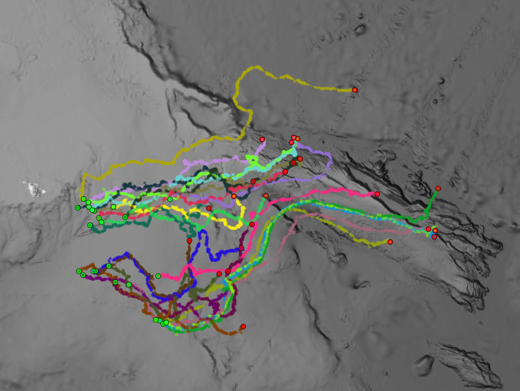
Overview map of tagged skates
Spatial extent
N
S
E
W
Provided by

Associated resources
Not available